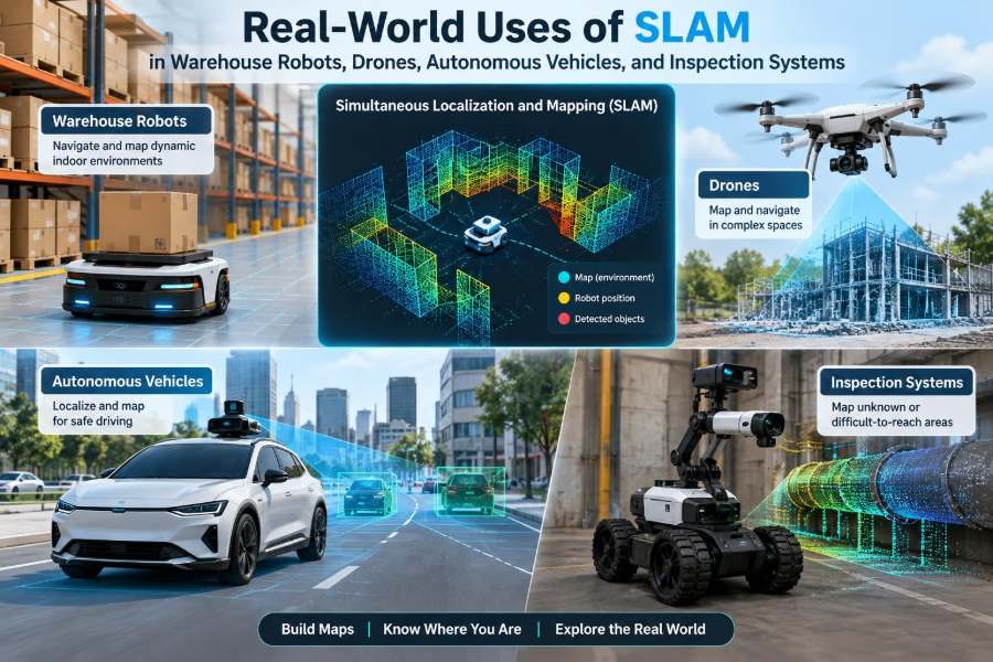

A warehouse robot turns into an aisle that was clear yesterday but is now partly blocked by a pallet. A drone enters a dim concrete tunnel where GPS disappears. An autonomous vehicle approaches a roadwork zone whose lane markings have changed overnight.
In each case, the machine needs more than a route. It needs a reliable answer to two questions: Where am I? and What does the world around me look like right now?
That is the practical role of simultaneous localization and mapping, usually called SLAM. It lets a robot build or update a map while estimating its own position within that map.
SLAM is not a single sensor or a finished product. It is a family of methods that connects sensing, estimation, mapping, motion planning, and safety. Its real value becomes clear when robots leave controlled demonstrations and encounter changing, imperfect physical environments.
🧭 What SLAM Means in Practice
“Simultaneous localization and mapping” describes a circular problem. To locate itself accurately, a robot needs a map; to create an accurate map, it needs to know where its sensors were when measurements were taken.
SLAM solves this by maintaining estimates of both at once. As new observations arrive, the system adjusts its best estimate of robot pose—position and orientation—and the map. The result is always uncertain, but it can become useful enough for navigation and task execution.
🗺️ The Map Is More Than a Floor Plan
A robot map is usually built for a purpose, not for human readability. A warehouse vehicle may need open travel corridors, rack boundaries, and docking features. A drone may need a three-dimensional model of walls, branches, and cables.
Maps can store landmarks, occupancy probabilities, point clouds, visual features, or semantic labels such as “door,” “forklift lane,” and “no-go zone.” The useful map representation depends on the decisions the robot must make.
📍 Localization Is a Continuous Estimate
Localization is often described as finding an exact coordinate, but real systems work with likelihoods. Wheel slip, sensor noise, vibration, moving people, and imperfect calibration all introduce error.
A sound SLAM system tracks confidence as well as location. When confidence falls, a robot may slow down, seek a familiar viewpoint, request assistance, or switch to a safer behavior instead of continuing as though its estimate were certain.
🧩 The Basic SLAM Loop
Most implementations repeat a recognizable loop: predict motion, observe the environment, match observations to the map, then correct the estimated pose and map.
- Prediction: odometry or inertial measurements estimate where motion should have placed the robot.
- Observation: cameras, lidar, radar, or other sensors measure surrounding structure.
- Association: the software decides which current features correspond to prior map features.
- Optimization: conflicting measurements are reconciled to reduce accumulated error.
This loop must run fast enough for the robot’s speed and safety requirements.
📡 Sensors That Feed a SLAM System
Lidar measures ranges to surfaces and is valuable for geometric structure. Cameras capture rich texture and can recognize visual features, but lighting and motion blur can be difficult. Inertial measurement units, or IMUs, measure acceleration and angular velocity at high rates.
Wheel encoders help ground vehicles estimate distance traveled, while radar can remain useful in rain, dust, or low-light conditions. No sensor is universally best; deployment conditions shape the sensor suite.
🔗 Why Sensor Fusion Matters
Individual sensors fail in different ways. A camera may struggle in darkness, while a lidar may see repeated shelf geometry without knowing which aisle segment it occupies. An IMU is responsive but drifts when used alone.
Sensor fusion combines complementary evidence. For example, an AMR can use wheel encoders for short-term motion, an IMU during bumps or turns, and lidar scan matching to correct drift against warehouse structure.
🏭 SLAM in Autonomous Mobile Robots
Autonomous mobile robots, often called AMRs, use SLAM to move materials through facilities without fixed guide wires or painted tracks. An initial mapping run may capture aisles, walls, pillars, and permanent equipment.
During operation, the robot compares live scans with that map. This enables flexible routes around temporary obstructions and supports deployment in buildings where rearranging infrastructure would be expensive or disruptive.
📦 Navigating Warehouse Aisles
Warehouse aisles are structured, but their regularity can be deceptive. Long parallel racks provide similar-looking surfaces, and merchandise, carts, and pallets change the visible scene throughout a shift.
A practical system separates stable structure from temporary obstacles. Rack uprights and walls may anchor localization, while people and pallets belong to a dynamic layer used for immediate avoidance. Treating every detected object as permanent would quickly corrupt the map.
🔄 Dynamic Maps for Changing Facilities
Facilities evolve: racks move, staging zones shift, and seasonal layouts appear. A map that never changes becomes a liability, but a map that accepts every temporary observation also becomes unreliable.
Many systems therefore use map versioning or layered maps. A stable base map represents enduring geometry, while a shorter-lived operational layer records temporary restrictions, blocked zones, or approved layout changes after validation.
🎯 Docking, Charging, and Fine Positioning
Traveling down an aisle may tolerate modest position error; docking under a conveyor or aligning charging contacts does not. Fine positioning commonly adds local sensors, fiducial markers, short-range lidar, cameras, or mechanical guidance.
This illustrates an important engineering point: SLAM often gets a robot to the right neighborhood, while task-specific localization handles the final centimeters. Designing for both stages is more reliable than expecting one global map to solve every alignment problem.
👷 People, Forklifts, and Safety Boundaries
SLAM provides location awareness, but it is not a complete safety system. A robot must still detect people and vehicles, maintain protective stopping behavior, and follow the site’s applicable risk assessment and safety controls.
Maps can define restricted zones and preferred routes, yet live perception must take priority when the physical world disagrees. A forklift parked in a mapped corridor is not a mapping error; it is an immediate navigation and safety condition.
🚁 Why Drones Need SLAM Indoors
Global navigation satellite signals can be weak, blocked, or unavailable inside buildings, under bridges, in forests, and underground. A drone cannot simply pause in midair to recover its bearings as a wheeled robot can.
Visual-inertial SLAM combines camera observations with IMU data to estimate rapid motion. It supports tasks such as indoor inventory scanning, structural documentation, and exploration of spaces where a human pilot has limited line of sight.
🌬️ Motion and Vibration in Aerial Mapping
Drones create difficult sensing conditions: fast turns, vibration from rotors, propeller wash, and exposure changes when flying between shadow and sunlight. Camera images can blur precisely when the aircraft makes an aggressive maneuver.
Engineers reduce these effects with rigid sensor mounting, careful time synchronization, calibrated camera-IMU geometry, and flight paths that preserve enough visual overlap. Better estimation cannot fully compensate for poor sensor data.
🏗️ Drones in Construction and Inventory Spaces
In a construction site, a drone can use SLAM to maintain a local three-dimensional understanding while documenting incomplete rooms, corridors, or ceiling infrastructure. The output may help compare observed geometry with planning information, although it should not be assumed to be a survey-grade record without appropriate validation.
In tall warehouses, aerial robots can localize around racks and collect observations at heights that are inconvenient for ground systems. Their routes must still account for narrow spaces, airflow, and the risk of flying near people or moving equipment.
🕳️ Underground and GPS-Denied Exploration
Tunnels, mines, utility corridors, and damaged structures often lack dependable external positioning. SLAM can produce a local coordinate frame from onboard sensing, enabling a robot to return to a starting point or report where observations were made.
These environments are especially demanding because dust, water, darkness, featureless walls, and confined geometry can degrade perception. Redundant sensing and conservative navigation are generally more valuable than a visually impressive map alone.
🚗 SLAM’s Role in Autonomous Vehicles
Road vehicles commonly use a combination of satellite positioning, inertial sensing, wheel measurements, cameras, lidar, radar, and detailed prior maps. SLAM-like localization helps match live observations—such as curbs, poles, buildings, and road geometry—to known surroundings.
Its role differs from warehouse navigation. Roads cover larger areas, speeds are higher, and the consequences of a localization mistake can be severe. This calls for redundancy, monitoring, and carefully defined operating conditions.
🛣️ High-Definition Maps and Live Perception
A high-definition map may encode lane boundaries, traffic-light locations, curb shapes, and other features useful for localization and planning. It is not a replacement for live sensing, because lanes can be repainted and work zones can appear.
Live perception answers what is happening now; the prior map adds context and supports precise localization. When the two disagree, the vehicle needs an explicit strategy rather than silently trusting one source in every situation.
🌧️ Weather, Seasons, and Map Drift
Rain, snow, glare, fog, fallen leaves, and changing vegetation alter what sensors observe. A route mapped in dry daylight may look substantially different at night or after a storm.
Robust systems use sensor diversity and detect when localization quality is declining. They may reduce capability, select a safer route, or hand control back within their intended operating design. SLAM reduces uncertainty; it does not eliminate environmental variability.
🔁 Loop Closure: Recognizing a Place Again
As a robot travels, tiny estimation errors accumulate into drift. Loop closure occurs when it recognizes that it has returned to a previously observed place and uses that evidence to correct the map.
Imagine walking around a city block while estimating every step. Seeing the original storefront gives you a chance to correct the accumulated error. In robotics, false loop closures are dangerous because two similar-looking places can be mistakenly treated as the same location.
🧱 Inspection Robots and Digital Context
Inspection systems use SLAM to attach observations to physical locations. A crawler detecting corrosion, a quadruped viewing pipes, or a robot scanning a tank can associate images and measurements with a map rather than producing an unorganized collection of files.
This context supports repeat inspections. Teams can compare the same region across time, plan access routes, and review findings without relying solely on an operator’s memory of where a defect was seen.
⚙️ Inspecting Plants, Pipes, and Confined Spaces
Industrial sites contain repetitive pipes, reflective metal, narrow passages, and limited lighting—conditions that challenge both lidar and cameras. A robot may need to combine geometric sensing with visual cues, inertial data, and known plant layout information.
Inspection results should also preserve uncertainty. If a reading is associated with an approximate rather than precise location, the system should make that clear so maintenance teams do not treat estimated coordinates as exact.
🌊 Infrastructure Inspection Beyond Buildings
SLAM is also useful around bridges, culverts, rail corridors, dams, and water-adjacent structures. Drones and ground robots can collect repeated views of surfaces that are difficult to access manually.
However, collecting a map is not the same as diagnosing structural condition. Interpretation may require domain-specific procedures and qualified personnel. SLAM provides spatial organization and navigation; it does not independently determine whether a crack or deformation is hazardous.
🧠 Semantic SLAM Adds Meaning
Traditional SLAM emphasizes geometry: points, planes, and free space. Semantic SLAM adds categories and relationships, such as identifying a loading dock, fire door, valve, or pedestrian crossing.
Meaning can make maps more actionable. A warehouse robot can reason differently about a temporary pallet and a fixed support column. Yet semantic models can misclassify objects, so critical decisions still need confidence checks and, where appropriate, conservative fallback behavior.
⏱️ Timing and Calibration Are Hidden Requirements
A camera frame and an IMU measurement only help each other if the system knows when each was captured. Even small timing offsets can matter on a fast-moving drone or vehicle.
Sensor calibration is equally important. The system must know the relative position and orientation of each sensor, as well as relevant camera or lidar parameters. Poor calibration often appears as mysterious drift, warped maps, or unstable localization.
💻 Compute Limits Shape the Design
Dense three-dimensional mapping, object detection, path planning, and safety monitoring compete for onboard computing resources. More data is not automatically better if it cannot be processed with predictable latency.
Engineers choose resolutions, update rates, and map detail based on the task. A low-speed inventory robot may accept a different tradeoff than an inspection drone that needs responsive obstacle avoidance in tight spaces.
🧪 Testing Beyond the Happy Path
Testing SLAM only in a clean, empty environment hides the conditions that cause field failures. Useful tests include altered lighting, blocked landmarks, wheel slip, dust, repeated geometry, network loss, and deliberate map changes.
Simulation can expose many edge cases safely, but real-world testing remains necessary because sensor artifacts and environmental interactions are difficult to model completely. The objective is not to prove perfection; it is to understand failure modes and safe responses.
⚠️ Common Deployment Mistakes
- Assuming a one-time mapping run will remain valid indefinitely.
- Using a map optimized for navigation as though it were a metrology-grade measurement model.
- Ignoring sensor cleaning, mounting stability, and calibration maintenance.
- Confusing localization confidence with obstacle-detection confidence.
- Failing to define what the robot should do when it becomes lost.
These mistakes are operational as much as algorithmic. A capable SLAM stack still depends on site preparation, maintenance, monitoring, and realistic escalation procedures.
🛟 Designing Graceful Failure Behavior
Every production robot needs a plan for degraded localization. Depending on its risk profile and environment, appropriate actions may include slowing down, stopping in place, retreating along a confirmed path, requesting remote support, or transitioning to a simpler local behavior.
The right response depends on the task. A robot carrying goods in a segregated aisle may have options that an aerial robot near people does not. Fail-safe behavior must be designed with the entire system, not added after mapping works.
📏 Choosing the Right SLAM Approach
Selection begins with the environment and required outcome. Ask whether the space is indoor or outdoor, static or dynamic, well-lit or dark, planar or fully three-dimensional, and whether global coordinates are necessary.
| Use case | Common emphasis | Key challenge |
|---|---|---|
| Warehouse AMR | Lidar or lidar-camera fusion | Dynamic aisles and repeated structure |
| Indoor drone | Visual-inertial estimation | Fast motion and GPS denial |
| Road vehicle | Multi-sensor localization with prior maps | Weather and high-consequence errors |
| Inspection robot | 3D mapping and measurement association | Confined, reflective, or feature-poor areas |
The table is a starting point, not a prescription. Hardware, lighting, operating speed, and safety requirements can change the best choice.
🤝 SLAM Works Best as Part of a System
SLAM is most effective when it is connected to route planning, obstacle avoidance, task logic, fleet management, and human operations. A robot needs a trustworthy way to report uncertainty, receive map updates, and recover from exceptions.
The central lesson is straightforward: SLAM turns sensor data into spatial understanding, but useful autonomy comes from pairing that understanding with task-aware decisions and safe limits. Whether it guides a pallet mover, a drone, a road vehicle, or an inspection crawler, the goal is not merely to make a map—it is to act responsibly in a changing place.
Real-world SLAM succeeds when robots can recognize both what they know and when they no longer know enough to proceed safely. That combination of spatial intelligence and operational humility is what makes autonomy practical. 🦾🗺️🚁