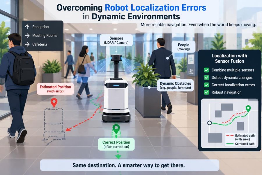

A warehouse robot leaves its charging dock with a precise map, a healthy battery, and a destination across the floor. Then a pallet is moved, a forklift passes close by, and workers gather near an aisle entrance. Within seconds, the robot’s confident estimate of where it is can become slightly wrong.
That small error matters. A delivery robot that believes it is 30 centimeters to the left of its true position may stop unnecessarily, take a poor route, or approach a docking station at the wrong angle. In tighter spaces, localization error can become a safety and reliability problem.
Dynamic environments make localization difficult because the world a robot senses is not the fixed world stored in its map. People, vehicles, doors, carts, lighting, and even sensor surfaces can change from moment to moment.
Reliable robots do not eliminate uncertainty. They measure it, manage it, and make cautious decisions when their own position estimate becomes questionable.
📍 What Robot Localization Actually Means
Localization is the process of estimating a robot’s pose: its position and orientation within a reference frame. For a ground robot, pose is commonly expressed as x-position, y-position, and heading angle.
The estimate may be relative to a local starting point, a building map, or global coordinates. Navigation depends on it: planning needs to know where the robot starts, control needs to know where it is moving, and safety logic needs to know what lies around it.
🧭 Why a Map Is Not Enough
A map provides expected structure, not a guarantee that the current scene matches that structure. A map may show walls, shelves, and permanent pillars, while the live environment contains temporary stock, parked equipment, or open doors.
Localization systems compare current sensor observations with expected features. When temporary objects dominate those observations, the robot can accidentally align itself to the wrong evidence.
🌪️ What Makes an Environment Dynamic
“Dynamic” does not only mean fast-moving. A space is dynamic whenever meaningful features change during operation, whether over milliseconds or over a work shift.
- Pedestrians and other robots move unpredictably.
- Furniture, pallets, and tools are relocated.
- Doors open and close, changing both geometry and sightlines.
- Lighting, weather, dust, and reflections alter sensor measurements.
- Construction or seasonal layouts make an older map incomplete.
The localization challenge is deciding which observations represent stable place information and which observations should be treated as temporary clutter.
📉 How Small Errors Become Large Ones
Localization errors often accumulate gradually. If wheel encoders slightly overestimate travel distance, each motion update shifts the estimated pose a little farther from reality. This process is called drift.
A later sensor correction can pull the estimate back toward the correct location. But if that correction uses ambiguous or moving features, it can instead produce a sudden incorrect jump. Both slow drift and abrupt jumps deserve separate monitoring.
🛞 Odometry and the Reality of Wheel Slip
Odometry estimates motion from wheel rotations, steering angles, or leg motion. It is fast, inexpensive, and available even when external sensors have a poor view.
Its weakness is that it assumes motion at the contact surface is well represented by wheel movement. Slippery floors, carpet transitions, ramps, aggressive turns, wheel wear, and collisions violate that assumption. A robot may report forward progress while its wheels are spinning in place.
Odometry is therefore useful as a short-term prediction, not as a permanent source of truth.
🌀 IMUs Help, but They Also Drift
An inertial measurement unit, or IMU, measures acceleration and angular velocity. It can capture rapid turns and brief motion that wheel sensors miss, making it valuable during fast maneuvers.
However, acceleration must be integrated over time to obtain velocity and position. Tiny bias errors are amplified by integration. IMUs are best used in combination with other sensors that periodically constrain long-term drift.
📡 LiDAR Sees Geometry, Not Meaning
LiDAR measures distances by emitting laser light and timing or analyzing returns. It is especially effective at detecting walls, corners, and other geometric structure, which makes it a common localization sensor indoors.
Yet LiDAR does not inherently know whether a cluster of points is a permanent shelf or a person carrying a box. If scan matching treats every return as stationary structure, a crowd or passing forklift can distort the alignment.
📷 Cameras Add Rich Context
Cameras provide texture, color, and semantic clues that range sensors may not capture. A vision system can potentially distinguish a wall sign from a person, or recognize stable markings in an otherwise repetitive corridor.
Camera-based localization is sensitive to illumination, glare, motion blur, lens contamination, and visual similarity. A glossy floor can create misleading reflections; a dim loading bay can remove the features the algorithm expected to see.
📶 Radar and Other Complementary Sensors
Radar can remain useful in conditions that challenge cameras and some optical sensors, such as rain, fog, or airborne dust. It also measures relative velocity well, which can help identify moving objects.
Its lower spatial detail can make precise indoor geometric alignment harder than with high-resolution LiDAR. The practical lesson is not that one sensor wins universally, but that different sensing modalities fail in different ways.
🧩 Sensor Fusion Combines Partial Evidence
Sensor fusion combines predictions from motion sensors with corrections from environmental observations. A fused estimate can be more stable than any individual sensor because one source can compensate when another becomes unreliable.
Common estimators include Kalman-filter variants, particle filters, and factor-graph methods. Their mathematical forms differ, but each attempts to balance prior belief, new measurements, and uncertainty rather than blindly accepting a single reading.
⚖️ Uncertainty Is a Useful Output
A localization system should publish more than a best pose. It should also express how uncertain that pose is. Uncertainty may be represented as a covariance, a cloud of weighted particles, or confidence measures tied to the estimator.
A robot that says “I may be anywhere within this corridor” is safer than one that reports an exact-looking but unjustified coordinate. Downstream behavior can then slow down, seek better observations, or request assistance.
🗺️ The Difference Between Localization and Mapping
Localization estimates where the robot is in a known map. Mapping estimates the environment’s structure. SLAM, simultaneous localization and mapping, estimates both at once.
In dynamic facilities, it is tempting to let SLAM absorb every new observation. That can be harmful: temporary carts and people may become embedded in the map. A robust system separates durable infrastructure from short-lived occupancy whenever possible.
🏢 Build Maps Around Stable Features
Localization maps work best when they emphasize features unlikely to move: walls, columns, fixed machinery, ceiling structure, and installed reflectors or fiducial markers. A shelving unit may be stable in one facility and routinely reconfigured in another.
Before mapping, inspect the operational process rather than relying on building drawings. The relevant question is not “what exists today?” but “what is likely to remain recognizable during normal robot operation?”
👥 Detect and Reject Dynamic Objects
Dynamic-object filtering attempts to prevent moving observations from influencing localization. It may use consecutive scans, object tracking, semantic segmentation, motion cues, or a comparison against the static map.
For example, points that move consistently between LiDAR frames are poor candidates for matching against a permanent wall map. Filtering is imperfect, however: a stationary forklift is still temporary, and a person standing still can resemble a structural object for a short period.
🔎 Data Association Is the Hidden Challenge
Data association asks which current observation corresponds to which map feature. A line detected by LiDAR could be a wall, a shelf edge, or the side of a container. Associating it incorrectly creates a plausible but wrong correction.
Repetitive spaces are especially difficult. Long identical aisles can produce several poses that fit the same local scan. Systems need additional context, such as landmarks, route history, or camera features, before committing to one explanation.
🧱 Repetitive Aisles Create Aliasing
Perceptual aliasing occurs when different places look alike to the sensor. In a warehouse with repeated rack bays, a robot may observe nearly identical geometry at multiple locations.
A hypothetical robot that is one aisle off may still find a strong scan match and believe it has corrected itself. Designers can reduce this risk with distinctive markers at intersections, varied stable landmarks, or a map representation that uses longer-range context.
🔦 Lighting, Weather, and Surface Effects Matter
Environmental changes can alter sensor quality without changing the robot’s true position. Low sun can saturate a camera, rain can affect optical visibility, and reflective glass or polished metal can create unusual range returns.
These are not edge cases for outdoor delivery, agriculture, and industrial sites. Teams should test sensors under expected operating conditions, including transitions such as bright outdoors to a darker building entrance.
⏱️ Synchronization Errors Mimic Localization Errors
Sensor fusion assumes measurements are correctly timed. If a camera frame is paired with a robot pose from a fraction of a second earlier while the robot is turning, apparent features will not align with the map.
Clock synchronization, timestamp handling, latency estimation, and calibration between sensor coordinate frames are engineering essentials. Better algorithms cannot fully compensate for inconsistent timing or an incorrectly measured sensor mount.
📐 Calibration Keeps Frames Consistent
Every sensor observes from its own physical position and orientation. Extrinsic calibration defines the transform between that sensor frame and the robot body frame; intrinsic calibration describes sensor-specific properties such as camera lens parameters.
A LiDAR tilted slightly from the assumed orientation may produce systematic matching residuals. Recalibration is particularly relevant after impacts, maintenance, sensor replacement, or mechanical changes to the robot chassis.
🧠 Robust Estimation Limits Bad Measurements
Robust estimators reduce the influence of outliers: measurements that do not follow the expected error model. Instead of allowing one bad scan segment to pull the pose dramatically, the estimator can down-weight or reject it.
Gating by residual size, random-sample consensus methods, robust loss functions, and consistency checks are common tools. Thresholds must be tuned carefully: aggressive rejection can discard useful information, while permissive rejection lets clutter steer the estimate.
🚦 Let Confidence Change Robot Behavior
Localization quality should affect operational decisions. When confidence is high, a robot may travel normally. When uncertainty grows, it can reduce speed, increase obstacle margins, choose a landmark-rich route, or stop in a safe location.
A useful escalation policy might include:
- Continue normally while uncertainty remains within the validated operating range.
- Slow down and seek an informative observation when confidence declines.
- Re-localize using known landmarks or a designated recovery zone.
- Stop and alert an operator if the pose cannot be trusted for safe motion.
The exact thresholds depend on robot speed, workspace clearance, and the consequences of being wrong.
🛑 Separate Localization Failure from Obstacle Avoidance
Obstacle avoidance answers, “What is immediately in my path?” Localization answers, “Where am I in the larger environment?” Both are necessary, but one cannot fully replace the other.
A robot can avoid nearby people while being globally lost. Conversely, it can know its map location accurately but still need live sensing to avoid a newly placed cart. Designing these layers separately makes failures easier to diagnose.
🔁 Recovery Needs More Than a Reset Button
When localization is lost, restarting the estimator at an arbitrary pose can produce dangerous confidence. Better recovery methods use a broad set of candidate poses, a known dock, deliberate motion that reveals distinctive geometry, or operator confirmation.
Some systems maintain multiple hypotheses until evidence distinguishes them. This costs computation, but it is valuable in visually or geometrically repetitive spaces where a single guess would be premature.
🏷️ Landmarks Can Be Simple and Effective
Artificial landmarks such as fiducial tags, reflectors, or carefully placed visual markers can provide unambiguous reference points. They are particularly useful at docks, intersections, narrow passages, and transition zones where a bad pose has high consequences.
They introduce maintenance requirements: markers can be blocked, damaged, dirty, or moved. Use them as part of a resilient localization design, not as the only evidence the robot can understand.
🧪 Test the Cases That Break Assumptions
A clean demonstration route rarely reveals localization weaknesses. Validation should include normal traffic, blocked views, moved equipment, temporary layout changes, poor lighting, slippery surfaces, and sensor degradation where safe to simulate.
Record ground truth when practical, but also review qualitative failure behavior. Did uncertainty grow before the estimate became wrong? Did the robot slow appropriately? Could an operator understand why it stopped?
📊 Measure More Than Average Position Error
Average error can hide rare but operationally serious failures. Evaluate how quickly the system re-localizes, how often it becomes overconfident, whether it jumps between plausible poses, and how behavior changes during degraded sensing.
| Metric or observation | Why it is useful |
|---|---|
| Position and heading error | Shows geometric accuracy against a trusted reference. |
| Uncertainty calibration | Reveals whether reported confidence matches actual error. |
| Recovery time | Shows operational impact after ambiguity or loss. |
| Failure mode logs | Connects errors to conditions such as glare, traffic, or slip. |
Metrics should be tied to the task. Docking may demand accurate heading, while aisle-level routing may tolerate a wider position estimate.
🧰 A Practical Debugging Sequence
When a robot localizes poorly, resist changing every parameter at once. Start by checking whether the issue is physical, temporal, perceptual, or algorithmic.
- Inspect sensor mounts, fields of view, cleanliness, and calibration.
- Verify timestamps, transforms, and coordinate-frame conventions.
- Compare raw sensor data with the map in the suspected area.
- Check wheel slip and odometry against independent motion evidence.
- Review rejected and accepted measurements, not only the final pose.
- Reproduce the failure with recorded data before modifying estimator logic.
This sequence prevents a software tuning exercise from masking a loose sensor bracket or a timing bug.
⚠️ Common Design Mistakes
One frequent mistake is tuning for an ideal empty environment, then treating crowded operation as an unexpected exception. Another is publishing a single confidence score without identifying whether the uncertainty comes from drift, ambiguity, or sensor degradation.
Teams also sometimes overwrite a stable map too eagerly, use moving objects as landmarks, or set recovery thresholds only by intuition. A system should be conservative where errors can cause unsafe or expensive behavior, while avoiding needless stops in benign uncertainty.
🏭 Match the Strategy to the Deployment
An indoor hospital robot, an orchard vehicle, and an outdoor construction machine face different localization problems. Hospitals contain people and visual changes; orchards have seasonal appearance variation and uneven terrain; construction sites may change geometry daily.
There is no universal sensor stack or estimator setting. Start with the operating envelope: speed, clearance, expected dynamics, weather, lighting, task precision, maintenance capacity, and what the robot must do when its estimate becomes unreliable.
🤝 Human Operations Are Part of Localization
Operational practices can make a localization system far more reliable. Staff need clear rules for preserving designated landmarks, reporting moved markers, keeping dock regions clear, and recognizing when a stopped robot is asking for recovery rather than malfunctioning.
Good interfaces expose useful status without overwhelming operators. “Localization uncertain near loading bay; seeking dock marker” is more actionable than a generic fault code.
🔮 Design for Graceful Degradation
Robustness does not mean every sensor remains perfect. It means the robot has a safe, understandable response when evidence weakens. Redundant sensing, conservative motion, recovery zones, and clear stop conditions all support graceful degradation.
The goal is not to make a robot appear certain at all times. It is to ensure that uncertainty leads to behavior proportionate to risk.
🦾 The Core Principle: Trust Evidence, Not Assumptions
Dynamic environments expose the gap between a robot’s stored model and the physical world. Reliable localization closes that gap by combining complementary sensors, prioritizing stable features, rejecting misleading observations, and tracking uncertainty honestly.
Most failures are not solved by a single “better” sensor or a more complex filter alone. They are solved through the full chain: sound calibration, realistic maps, careful timing, robust estimation, task-aware safety behavior, and testing under real operational change.
A robot navigates dynamic spaces reliably when it knows not only where it probably is, but also when it may be wrong and what to do next.
Localization is a continuing judgment under uncertainty, not a coordinate produced once and assumed forever. Build systems that question weak evidence, recover deliberately, and behave safely while the world changes around them. 🧭🦾