
A robot vacuum leaves its charging dock, crosses a living room, slips beneath a chair, and returns without falling down the stairs. An autonomous warehouse cart turns into the correct aisle even when a pallet has been moved. A drone inspects a bridge while holding position in a gust of wind.
None of these machines experiences a room, aisle, or bridge as people do. Their sensors produce streams of numbers: distances, pixel values, acceleration, wheel rotations, and sometimes satellite signals. From those incomplete and noisy observations, the robot must infer what is around it and where it is within that space.
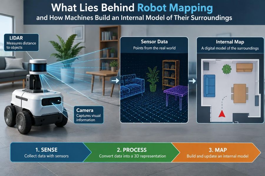
That process is called robot mapping. It is not simply drawing a floor plan. A useful map is a working internal model that helps a machine avoid hazards, plan routes, recognize change, and make decisions despite uncertainty.
Understanding mapping explains both the impressive behavior of modern robots and their occasional strange failures. It also reveals a central engineering challenge: a robot must often determine its location while it is still trying to build the very map needed to locate itself.
🗺️ Mapping Is More Than Drawing a Map
In robotics, a map is a representation of an environment created for a task. A robot that only needs to avoid walls may use a simple local obstacle map. A delivery robot that must revisit destinations needs a larger, persistent representation containing routes, landmarks, and restricted areas.
The best map depends on what the robot must do. A perfectly detailed three-dimensional model can be unnecessary if a two-dimensional occupancy map supports safe floor navigation. Conversely, a flat map is insufficient for a drone navigating around cables, branches, and building facades.
Mapping is therefore a trade-off among detail, memory, computation, update speed, and task relevance.
📍 Localization Answers the Other Half of the Problem
Localization means estimating the robot’s position and orientation, often called its pose. Position describes where it is; orientation describes which direction it faces. On a flat floor, pose commonly has three components: x position, y position, and heading angle.
A map without localization is like a paper city map with no indication of where you are standing. Localization without a map can work briefly, but errors accumulate and the robot cannot connect its observations to stable places.
Mapping and localization are tightly coupled. A robot needs an approximate pose to place new sensor data in the right location, yet it needs a map to improve that pose estimate.
🔄 SLAM Solves Mapping and Localization Together
Simultaneous Localization and Mapping, usually shortened to SLAM, is the family of methods used to solve this coupled problem. A SLAM system estimates the robot trajectory and builds or refines a map at the same time.
Consider a robot entering an unfamiliar office. It moves forward, observes a wall, turns past desks, and later sees the entrance again. SLAM tries to answer: where has the robot traveled, which observations refer to the same real-world features, and what arrangement of walls and objects best explains all observations?
SLAM does not produce unquestionable truth. It produces an estimate, usually with some representation of confidence. That uncertainty is fundamental, not merely a software inconvenience.
👁️ Sensors Give Measurements, Not Meaning
Robots perceive through sensors, and every sensor has blind spots. A lidar measures ranges to surfaces but may struggle with some reflective, transparent, or absorptive materials. A camera captures appearance but depends heavily on lighting and texture. A depth camera can measure nearby geometry but has limited operating conditions and range.
Other sensors describe motion rather than surroundings. Wheel encoders report rotation, an inertial measurement unit (IMU) measures acceleration and angular velocity, and global navigation satellite systems can offer outdoor position estimates.
Sensor readings must be interpreted. A camera pixel is not automatically a doorway, and a lidar return is not automatically a wall. Mapping software converts measurements into evidence about the world.
📡 Lidar Builds Geometry From Distance
Lidar emits laser light and measures the time or phase associated with its return. A scanning lidar produces many distance samples around the robot, forming a geometric snapshot of nearby surfaces.
In a corridor, successive scans may reveal two long parallel walls. In a warehouse, they may capture shelf edges, pillars, and pallet outlines. Matching scan geometry over time can provide a strong estimate of motion, especially in spaces with stable structure.
Lidar is widely used because distance measurements are directly useful for obstacle detection and geometric mapping. It is not magic, however: rain, dust, glass, repeating structures, and moving people can complicate interpretation.
📷 Cameras Map Appearance and Structure
Cameras offer rich information at relatively low hardware cost. They can detect visual features such as corners, edges, textured patterns, signs, and object boundaries. A robot may recognize that a distinctive poster or door frame has appeared before.
With a single camera, depth is inferred from movement and image changes, a technique often called visual odometry or monocular visual SLAM. Stereo cameras and depth cameras can estimate distance more directly by comparing views or using active sensing.
Vision can be exceptionally informative, but it is sensitive to darkness, glare, motion blur, shadows, and visually repetitive scenes. A plain white hallway gives a camera few reliable features to track.
🧭 Odometry Estimates Motion Between Observations
Odometry estimates how far a robot has moved from its own motion sensors. A wheeled robot may integrate encoder counts; a drone may combine IMU data with other measurements. This estimate is useful because it updates quickly between richer but slower environmental observations.
Its central weakness is drift. Slight wheel slip, an uneven floor, imperfect wheel diameter, or a small timing error can create a position error. Because each new estimate builds on previous ones, the error grows over distance.
Odometry is best understood as a prediction, not a final answer. Mapping systems continually correct it using observations of the external world.
📐 Coordinate Frames Keep Measurements Consistent
Robotics software uses coordinate frames to describe where measurements belong. A lidar has its own frame, a camera has another, the robot body has one, and the map has a global frame. Transformations convert a point expressed in one frame into another.
If the lidar is mounted slightly ahead of the robot’s center, that offset must be known. If it is tilted, its rotation must also be known. This process is called sensor extrinsic calibration.
Small calibration errors can create doubled walls, warped maps, or unreliable sensor fusion. Before tuning sophisticated algorithms, engineers should verify timestamps, frame conventions, and sensor mounting geometry.
🧩 Feature Maps Use Distinctive Landmarks
A feature-based map stores selected landmarks rather than every observed surface. A landmark might be a visual corner, a line intersection, a fiducial marker, or a recognizable pole.
When the robot sees a landmark again, it can compare the predicted and observed location. This helps correct its pose. Feature maps are often compact and useful when stable, distinctive landmarks are available.
The risk is ambiguity. Identical doors, repeated shelf bays, or similar-looking windows can be mistaken for one another. A robust system considers multiple clues instead of assuming that every similar observation is a match.
⬛ Occupancy Grids Represent Free Space and Obstacles
An occupancy grid divides space into small cells. Each cell stores an estimate of whether it is occupied, free, or unknown. For an indoor mobile robot, this is often a two-dimensional grid viewed from above.
As a range sensor detects a wall, cells along the sensor beam are updated as likely free, while the endpoint becomes likely occupied. Repeated observations strengthen or weaken those estimates.
Occupancy grids are practical because planners can directly use them to find collision-free paths. Their limitation is resolution: smaller cells capture finer detail but require more memory and processing.
🌐 Point Clouds Preserve Three-Dimensional Detail
A point cloud is a set of measured three-dimensional points. Spinning lidars, stereo systems, and depth cameras can generate point clouds that describe the shape of surfaces around a robot.
They are valuable for drones, legged robots, construction inspection, and manipulation, where height matters. A robot needs more than a floor plan if it must judge whether it can pass under a beam or grasp an object from a shelf.
Raw point clouds are often noisy and dense. Systems commonly filter them, remove ground surfaces, cluster objects, or convert them into more compact map structures.
🏗️ Semantic Maps Add Meaning to Geometry
Geometric maps answer questions such as “where is the nearest surface?” A semantic map adds labels and relationships: this region is a corridor, that object is a fire door, this area is a loading zone, and this is a charging station.
Semantics allow more useful behavior. A service robot can plan toward a named room; an industrial robot can avoid a safety zone; an inspection robot can report a defect relative to a known component.
Labels also introduce new failure modes. Object recognition can be uncertain, and a chair moved into a corridor does not turn the corridor into a chair permanently. Good systems separate durable map knowledge from temporary scene observations.
🧠 Probabilistic Reasoning Handles Uncertainty
Every measurement contains uncertainty. A range sensor has limited precision, a wheel may slip, and a visual match may be incorrect. Probabilistic mapping represents beliefs rather than treating every input as exact.
Instead of claiming “the robot is precisely here,” a system may maintain a distribution of plausible poses. New sensor data shifts that distribution toward locations that better explain the observation.
This approach matters when conditions are ambiguous. At a symmetric intersection, several poses may initially fit the available evidence. Prematurely selecting one can cause a confident but wrong map.
⚖️ Sensor Fusion Combines Complementary Evidence
Sensor fusion combines measurements from multiple sensors to produce a better estimate than any one source is likely to provide alone. An IMU captures rapid turns, encoders track short-term travel, and lidar or camera observations constrain long-term drift.
Fusion does not mean blindly averaging sensor outputs. Sensors have different update rates, coordinate frames, delays, error characteristics, and failure patterns. The software must account for these differences.
A practical design starts with the operational environment. A bright factory, a dusty mine, a dim hospital corridor, and an outdoor delivery route demand different sensor combinations.
🧮 Filters Update Estimates in Real Time
Many robots use filtering methods to update state estimates as data arrives. A filter predicts the next pose from motion, compares that prediction with a new measurement, and then adjusts the estimate according to the expected reliability of each.
Kalman-filter variants are common when state relationships can be approximated smoothly. Particle filters represent many possible poses, which can be useful when the robot may be uncertain about several distinct locations.
The exact algorithm matters, but the underlying pattern is more important: predict from motion, measure from the environment, and correct without assuming either source is flawless.
🕸️ Pose Graphs Reconcile a Long Journey
For larger environments, SLAM systems often use a pose graph. Nodes represent robot poses at selected moments, while edges represent constraints between them, such as “these two poses are connected by measured motion” or “these observations appear to be the same place.”
Optimization adjusts the graph so that its constraints fit together as consistently as possible. If early odometry drifted, the correction can be distributed across the robot’s path instead of creating one severe discontinuity.
Pose graphs are especially useful for revisiting places after long travel, where a local correction must be reconciled with an entire route.
🔁 Loop Closure Corrects Accumulated Drift
Loop closure occurs when a robot recognizes that it has returned to a previously mapped place. This is a pivotal SLAM event because it provides evidence that the current estimated trajectory has drifted.
Imagine a robot circling an office floor. Without loop closure, its final map may show the start and finish several meters apart even though they are the same doorway. A verified loop closure lets the system align those observations and refine the trajectory.
False loop closures are dangerous. Matching two similar hallways can bend or collapse a map incorrectly, so systems use geometric checks and consistency tests before accepting them.
🚶 Dynamic Objects Should Not Become Permanent Walls
People, forklifts, opening doors, and rolling carts move through many robotic environments. If a mapping system inserts every observation into a permanent map, it can gradually fill useful routes with ghost obstacles.
Robots often maintain separate layers: a stable map for lasting structure, a local cost map for current hazards, and sometimes a short-lived dynamic-object tracker. The planner responds immediately to a person crossing its path without rewriting the building layout.
This distinction is essential in public spaces and warehouses, where safe navigation depends on reacting to change as well as remembering structure.
🪞 Difficult Surfaces Challenge Range Sensors
Glass doors, mirrors, polished metal, water, and dark absorbent materials can produce unexpected sensor behavior. A laser may pass through glass, reflect away from the receiver, or return from an unintended direction. A camera may confuse reflections with real scene features.
There is no universal fix. Engineers may combine sensing modalities, reduce speed near known difficult areas, add physical markers, tune detection thresholds, or design routes that avoid repeated ambiguity.
Testing must include the actual surfaces and lighting of deployment. A map that works in a tidy laboratory can fail in a lobby filled with glass partitions.
🌦️ Outdoor Maps Must Cope With Change
Outdoor robots face seasonal vegetation, construction work, parked vehicles, rain, low sun, and satellite-signal obstruction. A curb that was clearly visible in summer may be hidden by leaves or snow later in the year.
Global satellite positioning can help constrain long-range travel outdoors, but accuracy and availability vary with sky visibility and reflected signals. Local sensing remains necessary for obstacle avoidance and precise positioning.
Long-lived outdoor mapping usually requires map maintenance. The system must distinguish a temporary truck from a redesigned road layout and know when old information should be reviewed.
🧹 Map Maintenance Prevents Stale Knowledge
A map is not automatically a permanent asset. Buildings are renovated, shelves are reconfigured, and access rules change. If a robot relies on stale geometry or outdated semantic labels, it may plan inefficient routes or approach restricted areas.
Maintenance can be scheduled, triggered by repeated mismatches, or supported by human review. Some systems retain confidence scores or timestamps so frequently confirmed features gain trust while unobserved features become less certain.
The appropriate update policy depends on risk. A changed office decoration is minor; a moved safety barrier or altered loading-bay route deserves faster attention.
🛣️ Maps Enable Planning, But They Do Not Drive the Robot
Mapping is only one part of autonomy. A planner uses the map to choose a route, while a controller turns that route into steering, wheel, or flight commands. A perception system continues detecting immediate hazards along the way.
A global planner may find a route from one room to another using the building map. A local planner then adjusts around a cart left in the corridor. The controller keeps the robot near the selected path without abrupt or unstable movement.
Separating these roles makes systems easier to test. When behavior is poor, engineers can ask whether the map, localization, route choice, obstacle interpretation, or control response is actually at fault.
⏱️ Latency Can Make a Good Map Unsafe
A map may be accurate but still unsafe if it arrives too late. Sensor processing, network transmission, optimization, and control all add delay. At higher speeds, a robot travels farther during that delay.
Real-time systems therefore balance map fidelity against timely action. A robot may use a detailed global map for strategic navigation and a fast, simpler local representation for immediate collision avoidance.
Time synchronization is equally important. Combining a camera frame from one moment with an IMU estimate from another can make stationary objects appear displaced.
🧪 Validation Requires More Than a Pretty Map
A visually convincing map is not sufficient evidence that a system works. Engineers should test localization repeatability, route completion, obstacle response, recovery after deliberate disturbance, and behavior when sensors degrade.
Useful test scenarios include:
- starting from different positions and headings;
- changing lighting, surface conditions, or traffic levels;
- introducing temporary obstacles and then removing them;
- checking recovery after wheel slip or a blocked route;
- testing loss of a primary sensor where a safe fallback is required.
Simulation helps explore conditions efficiently, but physical testing remains necessary because sensor artifacts and mechanical effects are hard to reproduce completely.
🚧 Common Mapping Failures Have Recognizable Causes
Maps that look duplicated, stretched, or misaligned usually provide clues. Repeated ghost walls may indicate calibration or timing problems. Gradual distortion often points to uncorrected drift. Sudden jumps can arise from a bad visual match or a false loop closure.
A disciplined debugging process avoids changing every parameter at once. First inspect raw sensor data, then verify transforms and timestamps, then check motion estimates, association logic, and map updates.
Engineers should also examine where failure occurs. A system that works in clutter but fails in blank corridors likely needs better handling of feature-poor scenes, not simply more aggressive optimization.
🛡️ Safety Demands Conservative Assumptions
For robots operating near people or valuable equipment, mapping uncertainty must influence behavior. If localization confidence drops, the robot may slow down, stop, request assistance, or switch to a simpler safe mode.
A map should never be the sole basis for assuming an area is clear. Current sensing is needed because people and objects can occupy spaces that the stored map represents as empty.
Safe autonomy combines redundancy, speed limits appropriate to sensing range, health monitoring, and clearly defined fallback actions. The right response to uncertainty is often not to guess more confidently, but to reduce risk.
🔧 Practical Design Choices Start With the Task
Students and professionals building a mapping system should begin with operational questions rather than selecting an algorithm by reputation. How large is the environment? Is it indoors or outdoors? Does the robot need centimeters of precision or only room-level awareness? How quickly does the environment change?
A useful early workflow is:
- define the navigation or inspection task and acceptable failure behavior;
- identify environmental challenges such as darkness, dust, glass, slopes, or repeated layouts;
- select sensors that provide complementary evidence;
- establish reliable calibration, timestamps, and coordinate frames;
- measure performance in representative conditions and iterate.
A modest, well-characterized system is usually more valuable than a complex architecture whose assumptions have never been tested.
🤝 Human Maps and Robot Maps Serve Different Purposes
Human maps often emphasize names, landmarks, and broad relationships: the cafeteria is behind the lobby, and the elevator is near reception. Robot maps may instead emphasize clearances, traversability, sensor landmarks, and uncertainty.
The two can be connected through semantic labels and interfaces. A human can instruct a robot to go to “Room 204,” while the robot translates that instruction into coordinates, routes, and collision constraints.
Designing that bridge carefully matters. A robot’s internal representation need not resemble a conventional floor plan, but its behavior and status should remain understandable to people supervising it.
🔮 Learned Maps Add Capabilities and New Questions
Machine-learning methods can help robots recognize places, segment objects, estimate depth, and predict traversability from sensor data. These capabilities can make maps more meaningful in complex scenes.
They also require careful evaluation. A learned model may perform differently when lighting, camera hardware, building style, weather, or object types differ from its development conditions. Confidence estimates and fallback behavior remain valuable.
Traditional geometric reasoning and learned perception are often complementary. Geometry provides measurable spatial constraints, while learned models can supply higher-level interpretation that geometry alone cannot easily provide.
🎯 The Core Principle: Build a Useful, Correctable World Model
Robot mapping succeeds when it creates a model that is useful for a specific decision and can be corrected as new evidence arrives. The goal is not to reconstruct every molecule of an environment or to eliminate all uncertainty.
Strong systems combine motion estimates with environmental observations, preserve the distinction between stable structure and temporary change, and treat confidence as information rather than an embarrassment. They also connect mapping to planning, control, safety, and maintenance.
The most capable robot is not the one with the most elaborate map. It is the one whose map remains reliable enough, current enough, and understandable enough to support safe action in the environment where it actually operates.
Robot mapping is the disciplined process of turning imperfect sensor evidence into a continually corrected internal model that lets a machine move, reason, and act safely. 🗺️🦾✨