
A delivery robot enters a concrete parking structure, where satellite signals fade. A warehouse vehicle turns down an aisle that looks almost identical to the last ten. A rover rolls into a tunnel after an earthquake, with nobody able to drive it by remote control.
In each case, GPS is unavailable, unreliable, or simply too coarse to tell the robot exactly where it is. Yet the robot still needs to avoid people, understand its surroundings, choose a safe route, and know whether it has reached the right place.
This is not a single-sensor problem. It is the practical challenge of autonomous navigation: estimating position, building or using a map, and making safe movement decisions when the world is messy and uncertain.
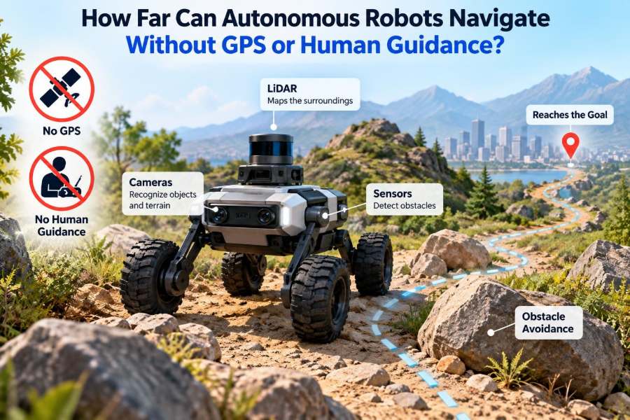
So how far can a robot travel without GPS or human guidance? The honest answer is: from a few meters to many kilometers, depending less on distance itself than on how well the robot manages accumulated error, environmental change, energy, sensing, and recovery from surprises.
🧭 GPS Is Helpful, Not a Complete Navigation System
Global Positioning System receivers estimate location from satellite signals. Outdoors, GPS can provide a useful global reference, especially when combined with correction services or other sensors. But it does not directly tell a robot whether a pallet blocks its path, whether it faces the correct direction, or whether a curb is safe to cross.
Even a robot with excellent GPS still needs local perception and control. Conversely, a robot can work without GPS if it has other ways to estimate motion and recognize where it is.
🏢 Why GPS Disappears in Real Workplaces
Buildings, tunnels, mines, dense forests, urban canyons, and underwater environments all interfere with satellite reception. Signals may be blocked, reflected, delayed, or too weak for a dependable position estimate.
Indoor robots face a second problem: ordinary GPS accuracy is often not precise enough for tasks such as aligning with a charging dock, picking from a shelf, or passing through a narrow doorway. A meter-scale error can be operationally significant.
📍 Navigation Means Knowing More Than Coordinates
A useful navigation system answers several related questions: Where am I? Which way am I facing? What is around me? Can I move safely? How do I reach my goal?
Engineers often describe the robot’s estimated location and orientation together as its pose. A pose might include x and y position on a floor plan plus heading, or a full three-dimensional position and orientation for a drone.
🔢 Distance Is a Poor Measure of Autonomy
A robot may travel a long distance in a simple, stable corridor with sparse obstacles and clear visual features. The same machine may struggle over a short route through a crowded lobby whose furniture has moved.
More revealing questions are these: How repetitive is the environment? How rapidly does it change? Does the robot have a trustworthy map? Can it detect and correct localization errors? What happens when one sensor fails?
⚙️ Dead Reckoning Starts With Motion Estimates
Dead reckoning estimates current position by adding measured movement to a known starting point. A wheeled robot, for example, can use wheel rotation to estimate how far it has traveled and how much it has turned.
It is fast, inexpensive, and always available while the wheels are moving. Its weakness is that every small measurement error becomes part of the next estimate. There is no automatic way to discover that the starting assumptions have gradually become wrong.
🛞 Wheel Encoders Work Until the Wheels Slip
Wheel encoders count wheel rotations. On clean, level flooring, this may produce a useful short-term motion estimate. But a wheel can slip on dust, loose gravel, wet surfaces, ramps, or during abrupt acceleration.
A robot might calculate that it moved forward half a meter while its wheels spun nearly in place. Encoder data is still valuable, but it should be treated as evidence rather than unquestionable truth.
📐 IMUs Sense Changes, Not Absolute Location
An inertial measurement unit, or IMU, contains accelerometers and gyroscopes. It senses acceleration and rotational motion at high frequency, helping a robot stabilize, estimate heading changes, and bridge brief gaps in other sensors.
To derive position from acceleration, the system must integrate noisy measurements over time, then integrate again for distance. Small biases therefore grow quickly. An IMU is excellent for short-term motion tracking, but by itself it rarely supports reliable long-range position estimates.
🧲 Compasses Have a Narrow but Useful Role
A magnetometer can estimate direction relative to Earth’s magnetic field. Outdoors and away from interference, it may provide a useful heading reference.
Inside industrial facilities, vehicles, steel shelving, electrical equipment, and reinforced concrete can distort the reading. A compass should not be assumed accurate merely because it reports a heading; calibration and environment-specific testing matter.
👁️ Cameras Turn Scenery Into Navigation Evidence
Cameras give robots rich information: corners, signs, textures, floor edges, doors, and landmarks. A visual navigation system can compare what it sees now with a map or with earlier images to estimate its motion.
Vision has practical limits. Bright glare, darkness, motion blur, dust, rain, blank walls, and repeating patterns can remove or confuse visual features. A camera-based robot needs suitable lighting and enough stable detail to observe.
🔦 LiDAR Measures Shape and Distance
LiDAR emits laser pulses and measures their return time to build a cloud of distance points. In a warehouse, its scans may reveal walls, rack legs, pallets, and openings even when visible-light conditions are poor.
Because geometry is often more stable than color, LiDAR is widely used for localization and obstacle detection. It can still struggle with some transparent, highly reflective, or absorbent surfaces, and its data can become ambiguous in long, repetitive corridors.
📡 Radar Adds Resilience in Difficult Weather
Radar uses radio waves and can remain useful in conditions that degrade cameras and some optical sensors, such as fog, rain, dust, or darkness. It is especially relevant for outdoor mobile robots and vehicles.
Its measurements typically provide less detailed shape information than high-resolution LiDAR or cameras, so radar is often paired with other sensors rather than used as the sole source of localization.
🗺️ Maps Give Measurements Context
A sensor reading becomes far more useful when it can be matched against a known environment. If a robot sees two perpendicular walls at a particular separation, a floor map may help it identify the room or corridor it occupies.
Maps may be simple line drawings, detailed three-dimensional point clouds, visual landmark databases, or semantic maps containing labels such as “loading bay” and “elevator.” The appropriate map depends on the job.
🧩 SLAM Lets Robots Map and Localize Together
Simultaneous localization and mapping, usually called SLAM, is the family of methods that lets a robot estimate its pose while building a map of an unfamiliar environment. As it moves, the robot compares new observations with previous ones and updates both its trajectory and map.
SLAM does not create certainty from nothing. It uses probabilistic reasoning to reconcile imperfect sensor data and motion estimates. The map and the location estimate improve each other when the environment provides recognizable structure.
🔁 Loop Closure Is How a Robot Corrects Its Past
Suppose a robot circles a large warehouse and recognizes the same loading dock it observed near the start. That recognition is called loop closure. It provides evidence that the estimated path has drifted and should reconnect with an earlier location.
Loop closure can substantially improve a map and reduce accumulated error. But false recognition is dangerous: two similar aisles can appear identical. Robust systems test geometric consistency and other constraints before accepting a match.
📏 Localization Drift Sets the Real Limit
Drift is the gradual difference between a robot’s estimated pose and its actual pose. It arises from wheel slip, sensor noise, weak map matches, timing errors, and imperfect calibration.
Without external correction, drift generally grows with travel and maneuvering. This is why an untethered robot can navigate briefly using dead reckoning yet eventually become uncertain about which room, aisle, or branch it occupies.
🧠 Sensor Fusion Reduces Single-Point Weaknesses
Sensor fusion combines information from several sensors into one estimate. For example, wheel encoders may estimate forward movement, an IMU may capture rapid turning, LiDAR may align scans to walls, and a camera may identify a doorway.
The benefit is not simply “more data.” Different sensors fail in different ways. A good fusion system weighs each measurement according to uncertainty and can reduce reliance on a source that becomes inconsistent.
| Navigation source | Strong use | Typical limitation |
|---|---|---|
| Wheel encoders | Short-term ground motion | Slip and uneven terrain |
| IMU | Fast attitude and turn tracking | Bias accumulates over time |
| Camera | Landmarks and semantic cues | Lighting and visual ambiguity |
| LiDAR | Geometric mapping and ranging | Repetitive geometry and surface effects |
| Radar | All-weather outdoor sensing | Lower-detail scene interpretation |
🏭 Structured Indoor Spaces Can Support Long Missions
Many warehouse robots operate for entire shifts without GPS because their work areas are bounded, mapped, and engineered for repeatability. The environment may include fixed rack geometry, designated traffic routes, known charging stations, and safety zones.
This does not mean the task is easy. Workers, carts, stock, and temporary barriers change constantly. But fixed infrastructure gives the robot frequent opportunities to correct its position rather than relying on a long chain of dead-reckoned motion.
🚇 Tunnels and Mines Remove Convenient Landmarks
Underground settings are more difficult because corridors can be long, visually uniform, dusty, and poorly lit. Branches may be sparse, and the most obvious geometry may repeat for hundreds of meters.
A robot can still travel substantial distances using LiDAR, inertial sensing, odometry, and map constraints. Confidence falls when it cannot revisit distinctive locations or observe enough variation to distinguish one segment from another.
🌲 Natural Terrain Changes the Problem Again
Forests, fields, and disaster sites offer irregular terrain, moving vegetation, variable lighting, mud, and loose material. Trees and rocks can help localization, but their visibility changes by viewpoint and season.
Legged robots, tracked vehicles, and wheeled rovers must also estimate traversability: not merely “Where am I?” but “Will this surface support the next step or wheel placement?” Navigation and mobility become tightly coupled.
🌊 Underwater Robots Navigate With Different Physics
GPS signals do not travel through water in a usable way, so underwater robots often combine inertial navigation, depth sensing, velocity measurements relative to water or seafloor, acoustic positioning, and sonar maps.
Acoustic systems can provide references over useful ranges, but sound travels slowly and is affected by environmental conditions and reflections. Long underwater missions are possible, yet position uncertainty remains a central planning concern.
🛩️ Drones Must Solve Navigation in Three Dimensions
A ground robot may be constrained by floors and walls. A drone must estimate altitude, roll, pitch, yaw, and position while managing airflow, vibration, and limited battery time.
Indoor drones often use visual-inertial odometry, which fuses camera observations with IMU data, along with depth sensors or LiDAR where payload allows. Feature-poor ceilings, narrow passages, and propeller-induced airflow can make the task demanding.
🚧 Dynamic Obstacles Are Not Map Errors
A static map can show where walls and permanent equipment belong. It cannot predict a person stepping into a path, a forklift backing out, or a door left open.
Reliable autonomy separates two jobs: localization, determining where the robot is, and local obstacle avoidance, responding to what is happening now. Confusing the two leads to brittle systems that assume the map is the world.
🧭 Planning Must Respect Uncertainty
Route planning selects a path, but a good robot also considers how confidently it can follow that path. A narrow shortcut through an uncertain area may be worse than a slightly longer route past known landmarks.
This is sometimes called active localization or information-aware planning. In practical terms, the robot deliberately visits places where its sensors can regain confidence, much like a hiker checking a trail sign rather than continuing through unfamiliar terrain.
🔋 Endurance Includes Computing and Recovery
Battery capacity is only one limit on how far a robot can operate. Cameras, LiDAR, onboard processors, cooling systems, communications, and locomotion all consume energy.
A robot that cannot localize confidently should have a recovery plan before its battery becomes critical. It may pause, retrace recent motion, seek a known landmark, return to a docking area, or request assistance through a defined safe procedure.
🛑 Safe Robots Know When Not to Continue
Autonomy should not mean relentless forward motion. When pose uncertainty exceeds a task-specific threshold, slowing down or stopping can be the safest action.
Common safety responses include reduced speed near people, obstacle-triggered stopping, geofenced operating boundaries, conservative fallback routes, and a controlled handoff to an operator. The correct response depends on the hazard, the robot’s mass and speed, and the operating environment.
🧪 Testing Requires More Than a Successful Demo
A robot that completes one clean run has not necessarily demonstrated dependable navigation. Tests should include changed lighting, moved objects, sensor occlusion, wheel slip, degraded maps, crowded periods, and loss of a primary sensor.
Teams should measure not only whether the robot reaches a destination but also how accurately it localizes, how quickly it detects uncertainty, and whether it enters a safe state when confidence is insufficient.
🧰 Practical Design Choices for GPS-Denied Robots
Start by matching sensing to the environment rather than selecting a fashionable sensor stack. A controlled warehouse may benefit from LiDAR and wheel odometry; a dim tunnel may need geometry-first sensing; an outdoor machine may require weather-tolerant redundancy.
- Define the required positional accuracy at each task, not as one vague global number.
- Identify repeated or featureless areas before choosing a localization method.
- Calibrate sensor placement, timing, and coordinate frames carefully.
- Maintain maps as facilities, layouts, and work rules change.
- Design explicit behavior for lost localization, low battery, and blocked routes.
⚠️ Common Assumptions That Cause Failures
One frequent mistake is treating a map as permanently correct. Another is assuming sensor specifications from a laboratory predict performance around reflective racks, dust, vibration, and human traffic.
Teams also underestimate coordinate-frame errors. If the camera, LiDAR, wheel base, and map use slightly inconsistent reference frames, the robot can appear to sense correctly while making systematically wrong movement decisions.
🤝 Human Guidance Is Often a Fallback, Not a Failure
Some missions require a person to intervene when the robot reaches an unfamiliar configuration or a safety boundary. That does not erase the value of autonomy; it defines a realistic operating envelope.
The goal is usually not to eliminate people from every exception. It is to make ordinary operation independent, make unusual cases understandable, and ensure that escalation is safe, timely, and infrequent enough for the application.
📈 How Far Can It Actually Go?
There is no universal distance limit. A robot with only encoders and an IMU may lose useful position accuracy after relatively modest travel, especially on slippery or irregular ground. A robot that repeatedly matches robust sensor observations to a maintained map can operate across a large facility or for extended missions.
For outdoor and remote systems, travel may extend much farther when they can use terrain maps, visual landmarks, radar, sonar, or other external references. The decisive factor is whether the system can periodically bound or correct its uncertainty.
🧩 The Core Principle: Correct Error Before It Matters
GPS-free navigation is not magic and is not merely a matter of installing more sensors. It is a continuing estimation problem: move, observe, compare, calculate uncertainty, correct drift, and choose actions that remain safe when the estimate is imperfect.
The most capable autonomous robots combine complementary sensors, environment-aware maps, careful calibration, conservative planning, and graceful recovery behavior. They are designed around the expectation that every estimate can be wrong.
An autonomous robot can navigate without GPS or continuous human guidance for as long as it can keep its uncertainty controlled, detected, and safely corrected. Distance follows from that capability—not the other way around. 🦾🧭🤖