
A warehouse robot rolls toward a pallet at the end of an aisle. A person steps into its path, a forklift crosses nearby, and a reflective strip on the floor catches the overhead lights. To move safely, the robot must recognize all of these changes in time.
It cannot rely on a single “eye.” It needs distance measurements, images, motion estimates, contact signals, and a way to judge how trustworthy each observation is.
This is the practical role of sensors in robotics: they turn physical events into data that control software can interpret. Sensors let robots estimate where they are, identify what surrounds them, and choose a safe next action.
Whether the platform is a self-driving vehicle, a surgical assistant, a delivery robot, or an industrial arm, navigation begins with perception. Good motion is built on good sensing. 🤖
🧭 1. Perception Is a Robot’s Starting Point
Perception is the process of collecting sensor data and converting it into useful information about the robot and its surroundings. Raw values alone are not enough; a camera pixel array or a stream of laser returns needs interpretation.
A robot commonly asks three questions: Where am I? What is around me? What will happen if I move? Sensors supply evidence for each answer.
📥 2. Sensors Turn Physical Quantities into Signals
A sensor measures a physical quantity such as light, acceleration, pressure, sound, magnetic field, or distance. It converts that quantity into an electrical or digital signal that a computer can process.
For example, a wheel encoder reports rotation, an accelerometer reports acceleration, and a depth camera estimates the distance of visible surfaces. Every measurement has limits, noise, and uncertainty.
🗺️ 3. Navigation Needs More Than Obstacle Detection
Seeing an obstacle is important, but navigation is broader. A mobile robot must estimate its position, represent free and occupied space, plan a route, and continuously correct its movement.
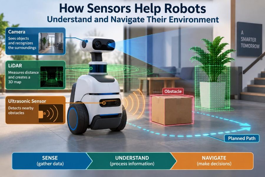
A useful navigation loop is:
- Sense the robot and environment.
- Estimate the current state.
- Build or update a map.
- Plan a safe path.
- Control motors and sense again.
Because the world changes, this loop runs repeatedly rather than only once at startup.
⚙️ 4. Proprioceptive and Exteroceptive Sensors
Roboticists often group sensors by what they observe. Proprioceptive sensors describe the robot’s own body, while exteroceptive sensors observe the external environment.
| Sensor category | Typical examples | Main purpose |
|---|---|---|
| Proprioceptive | Encoders, IMUs, joint sensors | Estimate motion, orientation, and configuration |
| Exteroceptive | Cameras, lidar, sonar, tactile arrays | Detect surfaces, objects, landmarks, and contact |
Reliable robots combine both categories. A map is less useful if the robot cannot tell how it has moved through it.
🔄 5. Wheel Encoders Measure Motion at the Wheels
Encoders measure shaft rotation. On a wheeled mobile robot, software converts wheel rotation into an estimate of traveled distance and turning angle.
This process is called odometry. It is fast and inexpensive, but it assumes the wheels roll as expected. Wheel slip, bumps, uneven floors, and small calibration errors cause the estimate to drift over time.
🌀 6. IMUs Sense Acceleration and Rotation
An inertial measurement unit, or IMU, typically contains accelerometers and gyroscopes. Accelerometers measure specific force, while gyroscopes measure angular velocity.
By integrating these measurements, software can estimate changes in velocity and orientation. Integration also accumulates small errors, so an IMU is powerful for short-term motion tracking but usually needs correction from other sensors.
🧲 7. Magnetometers Provide a Magnetic Reference
A magnetometer measures the local magnetic field. In suitable conditions, it can help estimate heading relative to Earth’s magnetic field.
Indoors, metal structures, motors, power cables, and electronic equipment can distort that field. Engineers therefore treat magnetometer data as one input among several, not as an unquestionable compass.
📷 8. Cameras Capture Rich Visual Context
Camera sensors provide detailed information about color, texture, edges, signs, people, and objects. They are especially useful when a robot must distinguish categories rather than merely detect a nearby surface.
A standard monocular camera does not directly measure distance. Algorithms can infer depth from motion, perspective, known object sizes, or learned visual patterns, but those estimates depend on scene conditions and model performance.
👁️ 9. Stereo Vision Estimates Depth Through Parallax
A stereo camera uses two cameras separated by a known baseline. Nearby objects appear at different horizontal positions in the two images, an effect called disparity.
After matching corresponding image features, the system can calculate depth through triangulation. Stereo works best where images have enough texture; blank walls, repeating patterns, and low light make correspondence difficult.
🌈 10. Depth Cameras Measure Range Directly
Depth cameras estimate distance for pixels in an image. Some use structured light, while others use time-of-flight methods that analyze emitted light returning from surfaces.
They can produce a dense depth image that is convenient for obstacle detection, manipulation, and indoor mapping. Strong sunlight, shiny materials, transparent surfaces, and cross-interference can reduce measurement quality.
🔦 11. Lidar Builds Precise Range Profiles
Lidar measures distance using laser light, often by timing a pulse’s return or by using related ranging techniques. Scanning lidar produces many distance points across a plane or volume.
The resulting point cloud can describe walls, shelves, vehicles, trees, and other geometry with strong spatial precision. Lidar does not inherently explain what an object is, so systems often pair it with cameras or learned classifiers.
📡 12. Radar Sees Motion in Difficult Conditions
Radar uses radio waves and can be effective in conditions that challenge optical sensors, including darkness, dust, fog, and some precipitation. It can also estimate relative velocity using Doppler effects.
Its spatial detail is often lower than a high-resolution camera or lidar, and reflections can be complex. For moving-object tracking, its range and velocity information can be particularly valuable.
🔊 13. Ultrasonic Sensors Handle Nearby Obstacles
Ultrasonic sensors emit sound above the usual range of human hearing and measure the echo delay. They are common on small mobile robots because they are simple and useful at short range.
Soft fabrics, angled surfaces, narrow objects, and multiple echoes can make readings ambiguous. A robot should use ultrasonic data conservatively, especially when people or fragile objects are nearby.
✋ 14. Tactile Sensors Confirm Physical Contact
Tactile sensors measure contact, pressure, force, or deformation. They are essential when a robot grips an object, opens a door, assembles components, or moves through a constrained space.
Touch gives information that vision alone may miss: whether an object has been grasped securely, whether a surface is compliant, or whether a collision has occurred. In manipulation, contact is often an expected and informative event.
💪 15. Force-Torque Sensors Protect Robots and Workpieces
A force-torque sensor measures forces and moments, often at a robot wrist or joint. It lets the controller detect resistance and adjust motion during insertion, polishing, or human-robot collaboration.
Rather than forcing a planned trajectory, an arm can use compliant control to yield safely when contact differs from expectation. This is critical when tolerances are small or objects vary slightly.
🎯 16. Landmark Sensors Support Repeatable Positioning
Some environments include deliberate landmarks such as printed visual markers, reflective targets, radio beacons, or recognizable structural features. A robot can use them as reference points to correct its estimated pose.
Landmarks are useful when repeatability matters, such as a robot returning to a charging station or an arm locating a fixture. They simplify localization but may require environmental preparation.
📍 17. Localization Estimates the Robot’s Pose
Localization estimates a robot’s pose: its position and orientation in a chosen coordinate frame. A delivery robot, for example, needs more than an approximate room location; it needs an estimate accurate enough to stay on a safe route.
Localization combines a motion prediction from encoders or an IMU with observations from cameras, lidar, radar, landmarks, or other environmental sensors. The result is always an estimate, not direct certainty.
🧩 18. Mapping Turns Measurements into Spatial Memory
A map stores information about the environment in a format useful to the robot. It may be a simple occupancy grid, a geometric point cloud, a semantic map, or a detailed three-dimensional model.
An occupancy grid divides the world into cells and records whether each cell is likely free, occupied, or unknown. This compact representation is widely useful for ground robots planning around obstacles.
🧠 19. SLAM Maps and Localizes at the Same Time
Simultaneous localization and mapping, usually called SLAM, addresses a circular challenge: a robot needs a map to localize, but it needs a pose estimate to build a map.
SLAM algorithms use repeated observations of features or surfaces to update both estimates together. When the robot revisits a known area, loop closure can reduce accumulated drift by recognizing that the current view matches a previous location.
🔗 20. Sensor Fusion Is Stronger Than a Single Sensor
Sensor fusion combines measurements from multiple sources. Each sensor contributes different strengths: encoders respond quickly, an IMU captures rapid rotation, cameras provide appearance, and lidar provides geometric range.
Fusion helps compensate when one sensor becomes unreliable. A camera may struggle in darkness, while lidar still returns geometry; an encoder may drift during slip, while visual or lidar observations can reveal disagreement.
📊 21. Filters Manage Noise and Uncertainty
Sensor outputs are affected by random noise, bias, delays, and occasional false readings. A filtering method combines prior knowledge with new measurements, giving more weight to evidence that appears reliable.
Common approaches include complementary filters, Kalman-filter family methods, particle filters, and optimization-based estimators. The right choice depends on the robot model, sensor behavior, computational budget, and required accuracy.
⏱️ 22. Time Synchronization Matters
Sensor data is only meaningful when its timing is understood. If a camera image is paired with an IMU measurement from the wrong instant, a moving robot can infer incorrect feature positions.
Engineers record timestamps, account for sensor latency, and align streams before fusion. Fast robots and rapidly changing scenes make synchronization especially important.
📐 23. Calibration Connects Sensors to the Robot Frame
Calibration determines how a sensor’s measurements relate to reality and to other parts of the robot. It includes intrinsic properties, such as a camera’s lens model, and extrinsic properties, such as the camera’s position relative to the robot base.
A highly capable sensor mounted with an inaccurate transform can produce a consistently wrong map. Calibration must also be checked after impacts, maintenance, or hardware changes. 🔧
🌧️ 24. Real Environments Challenge Every Modality
Robots operate around changing light, reflective floors, dust, rain, vibration, clutter, people, and moving machines. No sensing technology performs perfectly across every surface and condition.
Common sensing challenges
- Glass and mirrors: can confuse optical range sensing and create misleading reflections.
- Sunlight and shadows: can reduce camera contrast or interfere with active optical sensors.
- Featureless surfaces: give vision systems little texture for matching.
- Dynamic objects: can corrupt maps intended to represent stable structure.
Robust designs anticipate these failure modes instead of treating them as rare exceptions.
🛑 25. Safety Requires Conservative Interpretation
For navigation, a false negative can be dangerous: the robot fails to detect an obstacle that is actually present. A false positive can be inconvenient: the robot stops for empty space.
Safety-oriented systems define confidence thresholds, maintain stopping margins, monitor sensor health, and provide fallback behavior. When perception becomes uncertain, slowing down or stopping can be the correct control decision.
🛤️ 26. Perception Feeds Planning and Control
Planning software uses maps and tracked obstacles to select a route. Local planners then adapt that route to nearby geometry and moving hazards, while low-level controllers command wheel speeds, joint torques, or steering.
The connection is continuous: sensing updates the world model, the world model changes the plan, and executed motion creates the next sensor view. Navigation is therefore a closed feedback loop, not a one-way pipeline.
🧪 27. Testing Must Include Failure Cases
Developers should test sensing in the environments where the robot will work, not only in ideal laboratory conditions. A system that performs well on a clean, static test course may fail around glare, crowds, uneven terrain, or sensor occlusion.
Useful tests include degraded lighting, partial sensor loss, unexpected objects, rapid maneuvers, dirty lenses, and communication delays. Simulation helps explore cases efficiently, while physical testing exposes hardware effects that models may miss.
🤝 28. Choose Sensors for the Task, Not the Trend
There is no universal best sensor suite. A vacuum robot, autonomous forklift, agricultural machine, inspection drone, and collaborative arm have different range, speed, cost, environment, and safety needs.
Engineers begin with operational questions: What must be detected? At what distance? How quickly can conditions change? What accuracy is necessary? What happens when a measurement is unavailable?
The best solution is often a carefully chosen combination of modest sensors, sound calibration, and software that understands uncertainty.
🏁 29. The Core Principle: Sense, Estimate, Act, Repeat
Sensors do not give robots human-like understanding by themselves. They provide incomplete, noisy observations from which software constructs a working estimate of the robot’s body, location, surroundings, and risks.
The central principle is simple: a robot navigates well when it repeatedly senses the world, estimates what those measurements mean, acts cautiously, and checks the result with new evidence. Better sensing is not just about adding hardware; it is about designing the full loop so that uncertainty is recognized and managed. 🦾🧭🤖