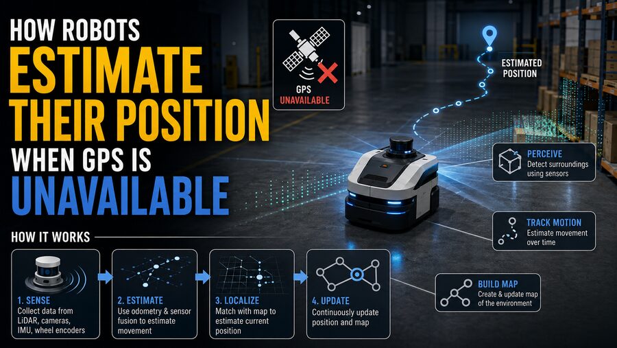

GPS is one of the easiest ways for a machine to determine where it is. A receiver listens to signals from satellites, calculates distances to them, and estimates its position on Earth. But robots frequently operate in places where GPS is weak, blocked, inaccurate, or completely unavailable. 🌍📡
Examples include:
- Warehouses
- Mines
- Tunnels
- Factories
- Underground facilities
- Dense urban streets
- Forests
- Indoor buildings
- Spacecraft
- Underwater vehicles
A robot moving through one of these environments still needs to answer a basic question:
“Where am I right now?”
Without that knowledge, it cannot navigate reliably, return to a charging station, avoid previously mapped obstacles, inspect specific locations, or plan a route to a destination.
To solve this problem, robots combine information from cameras, laser scanners, wheel encoders, inertial sensors, maps, and other sources. They continuously estimate how far they have moved, compare what they currently observe with what they observed earlier, and correct errors as new information becomes available.
This process is broadly known as robot localization. 🧭🤖
🧭 1. Localization Is the Robot’s Internal Position Estimate
A robot’s pose usually describes both its position and orientation.
In a simple 2D environment, pose may be written as:
x, y, θ
where:
x= horizontal positiony= vertical positionθ= heading angle
A flying robot may need a full 3D pose:
- X position
- Y position
- Z position
- Roll
- Pitch
- Yaw
The robot continuously updates these quantities as it moves.
This estimate is rarely perfectly exact. Instead, robotics systems usually maintain both a best estimate and some representation of uncertainty.
The challenge is to prevent that uncertainty from growing uncontrollably over time. 📊
🛞 2. Wheel Encoders Provide a Simple Form of Dead Reckoning
Many ground robots measure movement using wheel encoders.
An encoder measures how much a wheel rotates.
If engineers know the wheel diameter, they can calculate approximately how far the robot traveled.
Suppose a wheel has a circumference of 0.5 meters.
If the wheel completes 10 revolutions, the robot has theoretically traveled:
10 × 0.5 = 5 meters
For a differential-drive robot with left and right wheels, differences in wheel rotation can also reveal turning.
If both wheels move the same amount, the robot moves approximately straight.
If one wheel moves farther than the other, the robot turns.
By integrating these measurements over time, the robot estimates its path.
This technique is called odometry. 🛞
⚠️ 3. Dead Reckoning Accumulates Error
Wheel odometry is useful, but it is not perfectly reliable.
Suppose a wheel slips slightly on a dusty floor.
The encoder may report that the wheel rotated enough to travel 1 meter, even though the robot actually moved only 0.9 meters.
The localization system now contains an error of 0.1 meter.
More importantly, that error becomes part of the starting point for the next estimate.
As the robot continues moving, errors accumulate.
Potential sources include:
- Wheel slip
- Uneven floor surfaces
- Incorrect wheel diameter
- Tire deformation
- Encoder measurement noise
- Mechanical tolerances
This accumulation of error is known as drift.
A robot that relies entirely on dead reckoning may eventually become badly confused about where it is. 📉
🧠 4. Inertial Measurement Units Track Motion
Another important source of localization information is the Inertial Measurement Unit, or IMU.
An IMU commonly contains:
- Accelerometers
- Gyroscopes
- Sometimes magnetometers
Accelerometers measure linear acceleration.
Gyroscopes measure rotational velocity.
By integrating these measurements over time, a robot can estimate changes in velocity, orientation, and position.
For example, if a gyroscope detects that the robot is rotating at 30 degrees per second for 2 seconds, the robot may estimate that it has turned approximately 60 degrees.
IMUs are especially important in:
- Drones
- Autonomous vehicles
- Legged robots
- Mobile robots
- Spacecraft
Because they measure motion internally, they work even in darkness or environments without visible landmarks. 🚀
📉 5. IMUs Drift Too
Unfortunately, inertial navigation has the same fundamental problem as wheel odometry: small errors accumulate.
Suppose an accelerometer has a tiny constant bias.
When acceleration is integrated once, that bias affects velocity.
When velocity is integrated again, it affects position.
Over time, a very small sensor error can become a large position error.
Gyroscopes also drift.
If the orientation estimate becomes slightly wrong, the robot may begin projecting acceleration in the wrong direction, causing additional position error.
For this reason, IMUs are usually combined with external observations rather than used alone for long-term localization.
📷 6. Cameras Can Estimate Motion From the Environment
A camera provides another way to estimate movement.
Imagine a robot observing a chair, doorway, and wall corner.
As the robot moves, those objects shift across the camera image.
Software can track distinctive visual features between frames.
If a feature moves from one location in the image to another, the robot can infer something about its own motion.
This technique is known as visual odometry.
A simplified process is:
- Capture an image.
- Detect recognizable features.
- Capture the next image.
- Match features between frames.
- Estimate camera motion.
Repeated continuously, this produces a trajectory estimate. 📷➡️🧭
👀 7. Stereo Cameras Can Estimate Depth
A single camera can infer motion, but estimating absolute scale can sometimes be difficult.
A stereo camera system uses two cameras separated by a known distance.
This resembles human binocular vision.
An object appears at slightly different positions in the left and right images.
The difference, called disparity, can be used to estimate depth.
With depth information, the robot can more directly estimate:
- Distance to obstacles
- 3D landmark positions
- Its own movement through the environment
Stereo vision is commonly used in mobile robots, autonomous vehicles, and drones. 🚗🤖
🔦 8. LiDAR Provides Precise Geometric Measurements
Many robots use LiDAR, which stands for Light Detection and Ranging.
A LiDAR sensor sends out laser pulses and measures how long they take to return.
Because the speed of light is known, the system calculates distance.
A scanning LiDAR may generate thousands or millions of measurements forming a geometric representation called a point cloud.
As the robot moves, it compares new scans with previous ones.
If the walls, poles, shelves, and other structures shift in the measured scan, software can estimate how the robot itself moved.
This technique is often called LiDAR odometry or scan matching. 🔦
LiDAR performs particularly well in environments with strong geometric structure.
🗺️ 9. A Known Map Can Help the Robot Localize
If the robot already has a map, localization becomes easier.
Suppose an indoor delivery robot knows that:
- A hallway is 20 meters long
- A doorway is located on the left
- A corner appears 5 meters later
As the robot travels, its sensors observe walls and doorways.
The robot compares those observations with the map.
If its laser scan matches the geometry near one location particularly well, the robot can conclude:
“I am probably here.”
This is known as map-based localization.
The process continuously adjusts the robot’s pose estimate so that observed features align with known map features. 🗺️📍
🔄 10. What If the Robot Does Not Have a Map?
Sometimes a robot enters an unknown environment.
Now it has two problems:
- Determine where it is.
- Build a map of the environment.
These problems depend on each other.
To build an accurate map, the robot needs to know its position.
But to estimate its position accurately, the robot benefits from having a map.
The solution is called SLAM — Simultaneous Localization and Mapping. 🤖🗺️
SLAM allows a robot to build a map while estimating its own trajectory at the same time.
It is one of the foundational technologies behind autonomous robotics.
🧩 11. How SLAM Works
Imagine a robot entering a warehouse for the first time.
It sees:
- A wall
- Several shelves
- A doorway
- A support column
The robot records these as landmarks.
It then moves several meters.
Wheel encoders and IMU measurements estimate how far it moved.
The robot observes the landmarks again from a different perspective.
If the new observations do not perfectly agree with the predicted position, the SLAM system adjusts:
- The robot’s estimated trajectory
- The landmark positions
- The map
Over time, all observations are optimized together.
The result is a map and trajectory that are mutually consistent.
🔁 12. Loop Closure Corrects Long-Term Drift
One of SLAM’s most powerful ideas is loop closure.
Suppose a robot explores a large factory.
After 20 minutes, accumulated odometry error makes the robot believe it is 5 meters away from its true position.
Then it returns to a loading dock it visited earlier.
The robot recognizes the same:
- Pillar
- Door
- Wall pattern
- Shelf arrangement
It realizes:
“I have been here before.”
This observation creates a loop closure constraint.
The SLAM system can then correct the accumulated drift across the entire trajectory.
A distorted map may suddenly become much more consistent. 🔄✅
This is one of the main reasons SLAM can remain useful over long distances.
🧮 13. Sensor Fusion Combines Imperfect Measurements
No single sensor is perfect.
Wheel encoders drift.
IMUs accumulate bias.
Cameras struggle in darkness or repetitive environments.
LiDAR can have difficulty in large featureless spaces.
The solution is sensor fusion.
Sensor fusion combines several measurements to produce a better estimate than any one sensor could provide alone.
For example:
Wheel encoder:
“The robot moved about 1 meter.”
IMU:
“The robot turned about 5 degrees.”
Camera:
“The doorway shifted by this amount.”
LiDAR:
“The wall alignment indicates this pose.”
Together, these observations can produce a more accurate estimate. 🧠⚙️
📊 14. Kalman Filters Are Common Sensor-Fusion Tools
One famous mathematical technique is the Kalman filter.
A Kalman filter repeatedly performs two broad steps:
🔮 Prediction
Use a motion model and previous state to predict the robot’s next position.
📡 Correction
Use a new sensor measurement to correct that prediction.
For example:
The robot predicts that it moved 2 meters.
A camera observation suggests it moved 1.8 meters.
The filter combines these estimates based on their uncertainty.
If the camera measurement is highly reliable, the correction may be large.
If the camera measurement is noisy, the system may trust the motion prediction more.
This uncertainty-aware weighting is one reason Kalman filters are so useful.
🎲 15. Particle Filters Represent Multiple Possible Positions
Sometimes the robot’s location is highly uncertain.
Imagine a robot being switched on in a warehouse without knowing which aisle it is in.
Several places may look similar.
A particle filter can represent many possible robot poses simultaneously.
Each particle is one hypothetical position and orientation.
As the robot moves and receives sensor observations:
- Some particles become more likely.
- Others become less likely.
- Unlikely particles disappear.
- Likely regions receive more particles.
Eventually, the distribution may converge around the robot’s true location.
This approach is widely used for probabilistic localization. 🎯
🧱 16. Visual Landmarks Can Provide Strong Position References
Some robots use naturally occurring landmarks.
Others operate in environments where landmarks are deliberately added.
Examples include:
- QR codes
- AprilTags
- Reflective markers
- Fiducial targets
- Painted floor patterns
If the robot detects a known marker, it can obtain a strong position correction.
For example:
“Marker 27 is known to be at coordinate (14.2, 8.5).”
If the camera sees Marker 27 from a known angle and distance, the robot can estimate its own pose relative to it.
This is especially useful in warehouses and factories where the environment can be engineered for reliable automation. 🏭
📶 17. Radio Signals Can Provide Indoor Positioning
GPS is not the only radio-based localization method.
Indoor robots can sometimes estimate position using:
- Wi-Fi
- Bluetooth beacons
- Ultra-Wideband (UWB)
- RFID systems
UWB is particularly useful for high-accuracy indoor positioning.
Fixed anchors are installed at known locations.
The robot measures signal travel time or related ranging information to estimate distance to several anchors.
With enough anchors, it can calculate its position using a process similar in spirit to satellite navigation.
This can provide a valuable absolute position reference that corrects odometry drift. 📡
🏭 18. Warehouses Often Combine Several Localization Methods
An autonomous warehouse robot may use:
- Wheel encoders
- IMU
- LiDAR
- Map matching
- Visual markers
Wheel encoders provide smooth short-term motion estimates.
The IMU improves orientation tracking.
LiDAR compares the surroundings with a facility map.
Markers provide occasional absolute position corrections.
Together, these sensors allow the robot to drive accurately between shelves even though satellite signals may never reach inside the building.
⛏️ 19. Underground Robots Face Especially Difficult Conditions
Mining robots and tunnel-inspection machines operate in environments where GPS is completely unavailable.
They may also face:
- Darkness
- Dust
- Repetitive tunnels
- Uneven terrain
- Few visual features
These systems may rely heavily on LiDAR, radar, IMUs, and wheel odometry.
A 3D LiDAR system can map tunnel geometry.
An IMU tracks rapid motion.
Loop closure can recognize previously visited tunnel intersections.
Combining these measurements enables autonomous navigation far underground. ⛏️🤖
🌊 20. Underwater Robots Cannot Use Ordinary GPS Below the Surface
Radio signals used by GPS do not penetrate seawater effectively.
Autonomous underwater vehicles therefore need other localization techniques.
They may use:
- Inertial navigation systems
- Doppler Velocity Logs
- Sonar
- Acoustic beacons
- Pressure sensors
A Doppler Velocity Log, or DVL, uses acoustic signals to estimate vehicle velocity relative to the seafloor or surrounding water.
Depth can be estimated from water pressure.
Sonar can recognize seafloor features.
Acoustic transponders can provide external reference points.
These systems can maintain navigation even during long underwater missions. 🌊⚓
🚁 21. Drones Often Use Visual-Inertial Odometry
Drones are especially sensitive to localization errors because they move in three dimensions and can rapidly become unstable.
When GPS is unavailable indoors, many drones use visual-inertial odometry.
This combines:
- Camera observations
- Accelerometer measurements
- Gyroscope measurements
The IMU provides rapid motion estimates at high frequency.
The camera provides slower but more stable corrections based on visible features.
Together, they produce a reliable estimate of the drone’s motion through space. 🚁📷
This technology enables drones to fly through buildings, warehouses, caves, and other GPS-denied spaces.
🛰️ 22. Spacecraft Also Use Relative Localization
Spacecraft cannot always rely on Earth-based GPS.
Robotic spacecraft may estimate position and orientation using:
- Star trackers
- Sun sensors
- Gyroscopes
- Cameras
- Radar
- LiDAR
A star tracker recognizes patterns of stars and compares them with a catalog.
This provides a precise orientation reference.
During planetary landing or docking, cameras and LiDAR can estimate relative position to terrain or another spacecraft.
The same fundamental localization problem appears whether the robot is inside a warehouse or millions of kilometers from Earth. 🚀✨
🧠 23. Localization Systems Track Uncertainty
A sophisticated robot does not simply claim:
“I am at x = 5.2 meters.”
It may internally represent something closer to:
“I estimate x = 5.2 meters, with an uncertainty of approximately ±0.15 meters.”
This matters.
If localization uncertainty becomes large, the robot may:
- Slow down
- Search for landmarks
- Re-localize
- Request external assistance
- Avoid narrow passages
Robots that understand their own uncertainty can make safer decisions.
🚨 24. Robots Can Become “Lost”
Localization can fail completely.
This may happen if:
- The environment changes significantly
- Sensors are blocked
- Lighting changes dramatically
- Wheels slip for a long time
- The map is wrong
- Many locations look identical
When the robot’s estimated location no longer matches reality, it is effectively lost.
A recovery process called global localization may attempt to determine the robot’s position from scratch.
The system compares current sensor observations against many possible map locations.
Once a convincing match is found, normal tracking can resume.
🏙️ 25. GPS-Denied Navigation Is Also Important Outdoors
GPS failure is not limited to indoor environments.
Tall buildings can block or reflect satellite signals, creating urban canyons.
Forests can weaken satellite visibility.
Bridges and tunnels can interrupt reception.
Intentional jamming or interference can also make GPS unavailable.
Autonomous vehicles therefore combine GPS with:
- Cameras
- Radar
- LiDAR
- IMU
- Wheel-speed sensors
- High-definition maps
If GPS temporarily disappears, the vehicle can continue estimating its position from the remaining sensors. 🚗
🗺️ 26. Localization and Navigation Are Different Problems
Localization answers:
“Where am I?”
Mapping answers:
“What does the environment look like?”
Path planning answers:
“How should I reach my destination?”
Obstacle avoidance answers:
“How do I avoid hitting something right now?”
These functions work together but are distinct.
A robot may have an excellent map but still fail if it cannot localize itself accurately within that map.
Localization is therefore one of the foundations of autonomous navigation.
⚖️ 27. Different Sensors Have Different Strengths
Each localization technology has tradeoffs.
Wheel encoders
✅ Cheap and smooth
⚠️ Sensitive to slip
IMUs
✅ Fast and self-contained
⚠️ Drift over time
Cameras
✅ Rich environmental information
⚠️ Depend on lighting and visible features
LiDAR
✅ Accurate geometry
⚠️ Can be expensive and may struggle in featureless spaces
UWB
✅ Strong absolute indoor reference
⚠️ Requires installed infrastructure
The best localization systems typically combine complementary sensors rather than depending on one.
🧠 28. The Core Idea: Predict, Observe, Correct
Despite the complexity of modern robotics, GPS-free localization can be summarized with three words:
Predict → Observe → Correct
Predict 🔮
Estimate where the robot should be based on wheel motion, acceleration, and previous state.
Observe 👀
Use cameras, LiDAR, radio beacons, sonar, or other sensors to examine the environment.
Correct ✅
Compare those observations with a map or previous observations and adjust the estimated pose.
This loop may run dozens or hundreds of times every second.
Each correction prevents small errors from growing into large navigation failures.
🏁 Conclusion
Robots do not become helpless when GPS disappears.
Instead, they build their own internal estimate of position by combining motion sensing with observations of the surrounding world. 🤖🧭
Wheel encoders estimate how far a robot travels.
IMUs measure acceleration and rotation.
Cameras track visual features.
LiDAR measures surrounding geometry.
Radio beacons can provide absolute indoor references.
Underwater robots use sonar and acoustic positioning, while spacecraft may use stars and optical navigation.
Because every sensor contains noise and error, robots combine measurements using techniques such as Kalman filtering, particle filtering, visual-inertial odometry, scan matching, and SLAM.
SLAM is especially powerful because it allows a robot to construct a map while simultaneously determining where it is within that map.
Loop closure then helps correct accumulated drift when the robot recognizes a place it has visited before. 🔄🗺️
The essential challenge is not obtaining one perfect measurement. It is continuously combining many imperfect measurements into a position estimate that remains useful.
That leads to one of the central ideas of autonomous robotics:
A robot does not need to know its location with absolute certainty. It needs to estimate its location well enough, understand the uncertainty in that estimate, and keep correcting itself as new information arrives.
That is how machines navigate warehouses, mines, tunnels, buildings, oceans, and even space when no GPS signal is available. 🚀🌊🏭