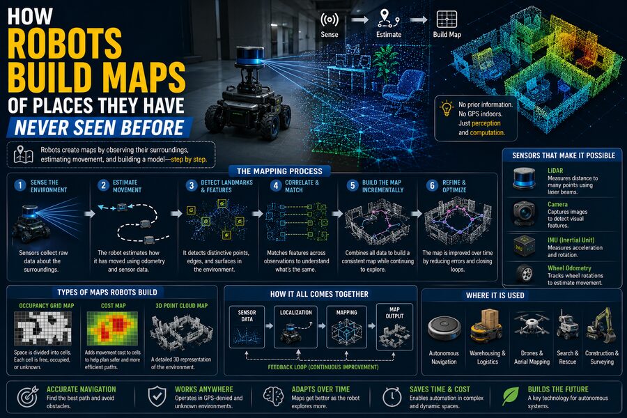

A robot entering an unfamiliar warehouse, cave, home, disaster zone, or planetary surface faces a fundamental problem:
How can it move safely if it does not already have a map? 🗺️
Humans solve this problem almost instinctively. We look around, notice walls and landmarks, remember where we came from, and gradually build a mental picture of the environment.
Robots must do something similar—but with cameras, lasers, radar, motion sensors, mathematics, and software.
One of the most important technologies that allows them to do this is called SLAM, short for Simultaneous Localization and Mapping.
SLAM allows a robot to answer two difficult questions at the same time:
“Where am I?”
and:
“What does the world around me look like?”
The challenge is that both questions depend on each other. To build a map, the robot needs to know where it is. But to know where it is, the robot often needs a map.
Solving that circular problem is one of the great achievements of modern robotics. 🤖🧠
🗺️ What Does It Mean for a Robot to “Build a Map”?
A robot map does not always look like a road map used by humans.
Depending on the robot and its mission, the map might represent:
- Walls
- Obstacles
- Doors
- Hallways
- Furniture
- Terrain
- Buildings
- Trees
- Rocks
- Free space
- Elevation
Some maps are two-dimensional.
Others are detailed 3D models.
A warehouse robot may need only a floor plan showing where it can drive.
A self-driving vehicle needs a much richer model containing lanes, curbs, traffic features, and nearby objects.
A drone flying through a building may construct a three-dimensional point cloud showing walls, ceilings, and obstacles.
The type of map depends on what the robot needs to accomplish.
👀 Robots Need Sensors to Observe the World
A robot cannot build a map without information about its surroundings.
It obtains that information through sensors.
Common mapping sensors include:
- Cameras 📷
- LiDAR
- Radar
- Sonar
- Wheel encoders
- Inertial measurement units
- Depth cameras
- GPS or other satellite navigation systems
Each sensor provides different information.
A camera captures rich visual details.
LiDAR measures distance very accurately.
Radar performs well in difficult weather.
Wheel encoders estimate how far the robot has moved.
An inertial measurement unit helps estimate rotation and acceleration.
Robotic mapping systems often combine several sensors because no single sensor is perfect.
🔦 How LiDAR Helps Robots See Geometry
LiDAR, short for Light Detection and Ranging, is one of the most important sensors used in robotic mapping.
A LiDAR device sends out laser pulses and measures how long they take to return after hitting surrounding objects.
Because the speed of light is known, the robot can estimate distance.
The result may look like thousands or millions of points representing nearby surfaces.
These collections are called point clouds.
A LiDAR-equipped robot can detect:
- Walls
- Shelves
- Vehicles
- Trees
- Buildings
- Furniture
- Terrain
By taking repeated scans while moving, the robot can gradually combine these points into a larger map.
📷 Cameras Can Build Maps Too
Robots do not always need lasers.
Cameras can also be used for mapping.
A camera captures images of the environment.
Computer vision algorithms identify important visual features such as:
- Corners
- Edges
- Textures
- Distinctive objects
Suppose a robot sees the corner of a poster on a wall.
It moves forward and sees that same corner again from a slightly different angle.
By comparing where the feature appears in multiple images, the system can estimate both the robot’s movement and the feature’s position in space.
This approach is often called visual SLAM.
🧭 Localization: The Robot Must Estimate Its Own Position
Mapping is only half the problem.
The robot must also estimate where it is.
This process is called localization.
Imagine a robot starts at an arbitrary point:
Position = (0, 0)
It drives forward one meter.
It might estimate:
Position = (1, 0)
Then it turns and moves again.
Its estimated position changes.
The problem is that motion estimates are never perfectly accurate.
A wheel may slip.
A floor may be uneven.
A sensor may contain noise.
Tiny errors accumulate over time.
This gradual growth of position error is called drift.
🛞 Wheel Odometry Helps Estimate Motion
Many ground robots use wheel encoders.
These sensors measure wheel rotation.
If the robot knows the wheel diameter, it can estimate how far it has traveled.
For example:
Wheel circumference = 0.5 meters
Wheel rotates 10 times
Estimated travel distance = 5 meters
This is called odometry.
Odometry is useful, but imperfect.
If a wheel slips slightly, the robot may think it traveled farther than it actually did.
Over a long journey, small errors can become large.
That is why odometry is usually combined with other sensors.
🌀 Inertial Sensors Track Rotation and Acceleration
Robots often contain an Inertial Measurement Unit, or IMU.
An IMU may include:
- Accelerometers
- Gyroscopes
- Sometimes magnetometers
Gyroscopes measure rotational motion.
Accelerometers measure acceleration.
Together, these sensors help the robot estimate how its orientation and motion are changing.
IMUs respond quickly and are useful between camera or LiDAR measurements.
However, inertial sensors also drift over time.
A tiny measurement error integrated repeatedly can eventually produce a large position error.
Sensor fusion helps compensate for these weaknesses.
🧠 Why SLAM Is Such a Difficult Problem
Suppose a robot sees a wall.
It records the wall’s position relative to itself.
But where is the robot?
If the robot’s own position estimate is wrong, the wall will be placed incorrectly on the map.
Later, the robot uses that map to estimate where it is.
Now an error in one part affects the other.
This creates a feedback problem.
SLAM algorithms continuously estimate:
Robot position + Map structure
and refine both as new observations arrive.
The system is constantly asking:
“Given everything I have seen so far, what is the most likely map and where am I within it?” 🎯
🔗 Matching New Sensor Data With Existing Maps
As a robot moves, it receives new sensor readings.
The system tries to align them with information already stored.
For LiDAR, this process may involve scan matching.
Suppose the robot captures one laser scan.
A moment later, it captures another.
Many walls and objects appear in both scans.
The software tries to determine how far the robot must have moved for the two scans to align.
This gives an estimate of motion.
The same principle applies to visual features in camera images.
📍 Landmarks Make Localization Easier
Distinctive features in an environment can act as landmarks.
A landmark might be:
- The corner of a doorway
- A lamp post
- A road sign
- A unique shelf
- A rock formation
- A visual pattern
If the robot sees the same landmark several times, it can use it as a reference point.
Suppose the robot originally estimated a landmark at:
(10, 5)
Later, it sees the landmark again.
That observation helps the robot correct its current location estimate.
More reliable landmarks generally improve localization.
🔄 Loop Closure: The Moment a Robot Recognizes a Familiar Place
One of the most important concepts in SLAM is loop closure.
Imagine a robot explores a large warehouse.
It travels through several corridors and gradually accumulates small position errors.
After 20 minutes, it returns to the place where it started.
The robot recognizes a familiar doorway.
It realizes:
“I have been here before.”
That realization is extremely valuable.
If its estimated map says the robot is several meters away from that original doorway, the system knows that accumulated drift has occurred.
It can then correct not only its current position, but much of the earlier map as well. 🔄
This is called loop-closure correction.
🧩 Map Optimization Corrects Earlier Errors
When loop closure occurs, the robot may need to adjust many previous position estimates.
Imagine the robot’s path was originally estimated as:
A → B → C → D → E
Then it discovers that point E is actually very close to point A.
The system can optimize the entire trajectory so that all measurements fit together more consistently.
This is often handled using mathematical techniques such as graph optimization.
The robot’s previous positions become nodes.
Measurements between positions become constraints.
Optimization finds the arrangement that best satisfies those constraints.
🕸️ Pose Graphs
A common SLAM representation is a pose graph.
A pose describes the robot’s estimated:
- Position
- Orientation
Each node in the graph represents a pose.
Connections between nodes represent observations or movement estimates.
For example:
Node 1 → Node 2: robot moved forward
Node 2 → Node 3: robot turned right
Node 50 → Node 1: robot recognized the starting location
That final loop-closure connection can help correct errors across the whole graph.
This makes graph-based SLAM extremely powerful.
🎲 Robotics Deals With Probability, Not Perfect Certainty
Sensor readings always contain uncertainty.
A LiDAR distance might be accurate within a few centimeters.
Wheel odometry may be less certain.
A visual feature might be incorrectly matched.
Robotics software therefore often uses probability.
Instead of saying:
“The robot is exactly here.”
it effectively says:
“The robot is probably somewhere around here, with this level of uncertainty.”
As more measurements arrive, the system updates that belief.
Probabilistic methods help robots remain robust even when sensors are noisy.
📊 Kalman Filters and Sensor Fusion
One famous technique for combining uncertain measurements is the Kalman filter.
Suppose wheel odometry says:
Robot moved 1.02 meters
but the camera suggests:
Robot moved 0.98 meters
The system can combine both estimates based on how reliable each sensor is believed to be.
The result might be near:
1.00 meter
Kalman-filter variants have historically been important in robotics, navigation, aerospace, and tracking.
More complex SLAM systems may use other optimization and probabilistic techniques, but the idea of combining uncertain measurements remains central.
🎯 Particle Filters Offer Another Approach
Another localization technique uses particle filters.
Imagine the robot maintains thousands of possible guesses about where it might be.
Each guess is called a particle.
Initially, the particles may be spread across a broad region.
As the robot receives sensor readings, guesses that match the observations become more likely.
Poor guesses gradually disappear.
Eventually, the particles cluster around the most probable location.
This is useful when a robot’s location is highly uncertain.
🧱 Occupancy Grid Maps
One common type of robot map is an occupancy grid.
The environment is divided into small cells.
Each cell stores information about whether that location is:
- Occupied
- Free
- Unknown
For example:
⬛ = obstacle
⬜ = free space
❓ = unexplored
As a robot moves, it updates the grid.
A laser beam traveling through open space suggests those cells are free.
If the beam hits a wall, the endpoint is marked as occupied.
Over time, a floor plan gradually appears.
🏠 Robot Vacuums Use This Principle
Modern robotic vacuum cleaners are a familiar example.
When first placed in a home, some models do not know the floor plan.
They move through rooms while using sensors such as:
- LiDAR
- Cameras
- Bump sensors
- Wheel encoders
The robot builds a map showing:
- Walls
- Rooms
- Obstacles
- Accessible floor space
Once mapping is complete, the vacuum can plan more efficient cleaning routes.
It may even allow users to identify rooms such as:
Kitchen
Bedroom
Living room
Mapping turns random movement into organized navigation. 🧹🤖
🚗 Self-Driving Vehicles Use Mapping at a Much Larger Scale
Autonomous vehicles also need detailed environmental understanding.
They may combine:
- Cameras
- LiDAR
- Radar
- GNSS
- IMUs
- Prebuilt maps
Unlike a simple warehouse robot, a self-driving vehicle must handle a dynamic environment containing:
- Cars
- Cyclists
- Pedestrians
- Traffic lights
- Construction
- Changing road conditions
Some autonomous systems use highly detailed maps created in advance.
Others rely more heavily on real-time perception.
In either case, localization is critical.
A vehicle must know precisely where it is relative to lanes, intersections, and obstacles.
🚁 Drones Can Map Buildings and Landscapes
Drones also use SLAM when GPS is unavailable or unreliable.
For example, a drone flying inside a warehouse cannot depend on satellite positioning.
Instead, it can use cameras, depth sensors, and inertial measurements.
As it flies, it builds a 3D model.
This allows the drone to:
- Avoid walls
- Navigate corridors
- Return to its starting point
- Inspect structures
- Explore unknown rooms
Similar techniques are used in mines, tunnels, and disaster zones.
🕳️ Robots Can Explore Mines and Caves
Underground environments are particularly challenging.
GPS signals do not reach deep into mines or caves.
Lighting may be poor.
Dust can interfere with sensors.
Terrain may be irregular.
Robots designed for underground exploration often rely on combinations of LiDAR, cameras, radar, and inertial sensors.
By building their own maps, they can navigate where no prior digital map exists.
This is useful for:
- Mining
- Search and rescue
- Geological research
- Infrastructure inspection
🚒 Search-and-Rescue Robots Need Maps Quickly
After an earthquake or building collapse, the environment may be completely different from existing architectural plans.
Walls may have fallen.
Passageways may be blocked.
Debris may create new routes.
A rescue robot can enter the damaged area and build a map in real time.
Human teams can use that map to understand:
- Safe pathways
- Blocked areas
- Structural hazards
- Possible victim locations
Robotic mapping can reduce the need to send people immediately into dangerous spaces.
🪐 Planetary Rovers Face an Extreme Mapping Challenge
Robots exploring other planets must also navigate unfamiliar terrain.
A rover on Mars cannot rely on a human driver reacting instantly because communication delays can be substantial.
The rover needs local autonomy.
Cameras and navigation sensors help it build terrain models.
The robot identifies:
- Rocks
- Slopes
- Sand
- Obstacles
- Safe routes
It can then select paths that reduce the risk of becoming stuck or damaged. 🪐
Robotic mapping is therefore essential for planetary exploration.
🧠 Semantic Maps Add Meaning to Geometry
Traditional maps might tell a robot:
There is an object here.
A semantic map tries to tell it:
That object is a chair.
or:
That area is a doorway.
Modern AI models can classify objects while the robot maps them.
This creates maps containing both geometry and meaning.
A service robot could understand:
- Kitchen
- Table
- Door
- Sofa
- Person
Semantic information allows robots to reason about environments in a more useful way.
🛋️ Why Semantic Understanding Matters
Suppose you tell a household robot:
“Bring me the book from the table.”
A purely geometric map containing anonymous obstacles is not enough.
The robot needs to understand what a table is.
It needs to identify likely tables, navigate toward them, detect the book, and plan a safe route.
Semantic mapping connects spatial navigation with AI-based object recognition.
This is an important step toward more capable general-purpose robots.
🚶 Dynamic Objects Make Mapping Harder
Not everything in the environment stays still.
People walk around.
Cars move.
Doors open and close.
Forklifts cross warehouses.
A mapping system should not permanently treat a passing pedestrian as part of the wall.
Modern SLAM systems try to distinguish static structures from dynamic objects.
Stable elements such as walls are valuable for mapping.
Temporary moving objects may need to be filtered out.
This is particularly important in crowded environments.
🌧️ Different Sensors Fail in Different Conditions
Every mapping sensor has weaknesses.
Cameras may struggle in darkness.
LiDAR can be affected by certain reflective or transparent surfaces.
Radar provides less detailed geometry.
Sonar may suffer from echoes.
Wheel odometry fails when wheels slip.
GNSS may disappear indoors.
For this reason, robust robots often use sensor fusion.
The weakness of one sensor can be compensated for by another.
🔗 Visual-Inertial SLAM
A common combination is cameras plus an IMU.
This is called visual-inertial SLAM or visual-inertial odometry.
The camera provides rich information about environmental features.
The IMU provides rapid estimates of rotation and acceleration.
Together, they can provide better motion tracking than either sensor alone.
This approach is useful for:
- Drones
- Mobile robots
- Augmented-reality devices
- Autonomous vehicles
📱 Your Phone Uses Related Technology
Modern smartphones and augmented-reality devices use mapping concepts similar to robotics.
When an AR application places a virtual object on your floor, the device must estimate:
- Where the phone is
- Where the floor is
- How the phone moves
The system tracks visual features and inertial motion.
This allows the virtual object to remain anchored in the same apparent location as the user moves around.
In a sense, the phone is building a small temporary map of the room. 📱✨
🥽 Virtual and Augmented Reality Depend on Mapping
Headsets also need precise tracking.
If a VR headset does not know exactly how the user’s head is moving, the virtual world will appear unstable.
Inside-out tracking systems use cameras mounted on the headset.
They observe the surrounding room and track visual features.
The headset builds a representation of the environment while simultaneously estimating its position.
That is closely related to SLAM.
🗺️ Mapping Is Only Useful If the Robot Can Navigate
Once the robot has built a map, it still needs to decide where to go.
This is called path planning.
Suppose the robot wants to reach a charging station.
The map tells it where obstacles are located.
A path-planning algorithm finds a safe route.
The robot may use algorithms such as:
- A*
- Dijkstra’s algorithm
- Sampling-based planners
- Local trajectory planners
Mapping answers:
“What does the environment look like?”
Planning answers:
“How should I move through it?”
🚧 Local Planning Handles Unexpected Obstacles
A global map may show a clear hallway.
But a person may suddenly leave a box in the middle.
The robot therefore needs local obstacle avoidance.
Its sensors continuously detect nearby changes.
The robot may slow down, go around the box, and then return to the original route.
Modern navigation combines:
Global map + Local perception + Real-time planning
This allows robots to operate in environments that change.
📈 Maps Can Improve Over Time
A robot’s first map may be imperfect.
As it revisits the same area, it collects more observations.
Repeated measurements can improve accuracy.
For example, one wall may initially appear slightly crooked due to sensor noise.
After several passes, the estimated wall position becomes more stable.
Some robots maintain maps continuously over days or months.
They may also learn which features are permanent and which change frequently.
🌍 Multiple Robots Can Build One Map Together
Teams of robots can cooperate.
Imagine ten robots exploring a large warehouse.
Each robot maps a different region.
Their maps can later be combined.
If two robots recognize the same location, their coordinate systems can be aligned.
Multi-robot mapping can speed up exploration dramatically.
It is useful in:
- Warehouses
- Mines
- Disaster response
- Agriculture
- Military robotics
- Planetary exploration
☁️ Cloud Systems Can Help Combine Maps
Robots do not always need to perform every calculation locally.
Some systems upload sensor data or partial maps to powerful servers.
Cloud software can:
- Merge maps
- Run computationally expensive optimization
- Share updates among robots
- Store long-term environmental models
However, cloud dependence introduces issues such as network latency, reliability, privacy, and security.
Critical navigation systems often retain enough local intelligence to continue operating if connectivity is lost.
⚡ Mapping Must Happen Fast Enough for Real-Time Navigation
A robot cannot spend several minutes processing each camera frame.
By then, it may already have crashed into something.
Mapping systems therefore need to operate close to real time.
The robot must process sensor data rapidly enough to:
- Estimate motion
- Detect obstacles
- Update the map
- Plan movement
This requires efficient algorithms and increasingly powerful onboard processors.
Modern GPUs and specialized AI chips make advanced robotic perception much more practical.
🔋 Mapping Also Consumes Energy
More sensors and processing power improve perception, but they consume electricity.
This matters for battery-powered robots.
A drone carrying several high-resolution cameras and LiDAR sensors may have excellent mapping capability but reduced flight time.
Engineers balance:
- Sensor accuracy
- Weight
- Computing power
- Battery usage
- Mission duration
Efficient robotics is always a systems-engineering problem.
⚠️ Maps Are Never Perfect
No robotic map is a perfect copy of reality.
Sensors have limited resolution.
Objects move.
Measurement errors occur.
Some areas remain hidden.
Reflective glass can confuse sensors.
Lighting conditions change.
Robots therefore need to reason under uncertainty.
A safe robot should not assume:
“The map says this area is empty, therefore it must be empty.”
It should continue sensing while moving.
Maps guide perception—they do not replace it.
🔐 Mapping Can Create Privacy Concerns
A household robot that maps a home may collect information about:
- Room layouts
- Furniture
- Daily routines
- Occupied areas
Commercial robots may map factories, offices, or warehouses.
These maps can contain sensitive information.
Developers therefore need to consider:
- Encryption
- Data retention
- Access controls
- Local processing
- User consent
Spatial data deserves the same security attention as other valuable digital information. 🔒
🧠 AI Is Making Robot Maps More Intelligent
Traditional SLAM focuses mainly on geometry.
Modern AI is increasingly helping robots understand context.
Instead of mapping only points and walls, future systems may represent:
“This is a kitchen.”
“That doorway probably leads to a hallway.”
“This object can be moved.”
“People frequently walk through this area.”
This richer understanding could make robots much more capable.
A robot may eventually build not just a geometric map, but a practical model of how a place works.
🏢 Example: A Warehouse Robot Mapping From Scratch
Imagine an autonomous robot enters a warehouse it has never seen before.
At first, most of its map is unknown.
Its LiDAR detects nearby shelves and walls.
Wheel encoders estimate forward movement.
The IMU tracks rotation.
The robot begins constructing an occupancy grid.
As it drives, new corridors appear.
It identifies visual landmarks.
Twenty minutes later, it returns near the starting point.
The robot recognizes the original loading bay.
Loop closure corrects accumulated drift.
The map is optimized.
The robot can now calculate efficient routes between storage zones.
A place that was completely unknown has become navigable through repeated observation and mathematical inference. 🤖📦
🧭 Exploration: How Does the Robot Decide Where to Map Next?
If the robot’s goal is to map an entire unknown environment, it must decide where to explore.
One useful concept is the frontier.
A frontier is the boundary between:
Known free space
and:
Unknown space
The robot can identify these boundaries and deliberately travel toward them.
Each frontier visit reveals more of the environment.
This approach is called frontier-based exploration.
Instead of wandering randomly, the robot systematically expands the known map.
🎯 Exploration Balances Information and Risk
The nearest unexplored area is not always the best one to visit.
A robot may consider:
- Distance
- Battery level
- Expected information gain
- Terrain difficulty
- Communication coverage
- Collision risk
A sophisticated exploration system chooses movements that reveal useful information while keeping the robot safe.
This turns map building into an optimization problem.
🤖 Why Autonomous Mapping Matters
Robots become dramatically more useful when they do not require humans to create every map in advance.
Autonomous mapping allows machines to enter:
- Newly built warehouses
- Unknown homes
- Collapsed buildings
- Remote caves
- Underground mines
- Distant planets
and begin operating with minimal prior information.
This adaptability is essential for robots expected to function in the unpredictable real world.
✅ The Bottom Line
Robots build maps of places they have never seen by combining sensor observations, motion estimates, probability, and continuous correction.
Cameras and LiDAR reveal surrounding geometry.
Wheel encoders and inertial sensors estimate movement.
SLAM algorithms simultaneously calculate the robot’s location and build a representation of the environment.
Landmarks help the robot recognize familiar places.
Loop closure corrects accumulated drift.
Optimization algorithms refine the map.
Path planners then use that map to navigate safely. 🗺️🤖
The process can be summarized as:
Sense → Estimate Motion → Add to Map → Recognize Places → Correct Errors → Explore Further
What makes the problem extraordinary is that the robot begins with almost nothing.
It does not know where the walls are.
It may not know where it is.
Yet with each laser scan, camera frame, wheel rotation, and movement, uncertainty shrinks and structure emerges.
Eventually, the unknown environment becomes a usable map.
That is how a robot vacuum learns the rooms of a house, how an autonomous drone explores a warehouse, how a rescue robot navigates rubble, and how a planetary rover reasons about terrain millions of kilometers from Earth. 🌍🪐
Robotic mapping is essentially the art of turning motion and observation into spatial understanding—allowing a machine to enter somewhere completely unfamiliar and gradually learn its way around.