
Robots do not “see” the world in the same way humans do. A person can look across a room and instantly recognize a chair, estimate how far away it is, notice someone walking toward them, and understand that a glass door is transparent. For a robot, every one of those abilities must be created through sensors, mathematics, software, and artificial intelligence.
Modern robots use technologies such as cameras, LiDAR, depth sensors, radar, ultrasonic sensors, and computer vision algorithms to build an understanding of their surroundings.
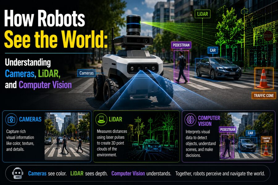
A camera can capture color and texture. LiDAR can measure precise distances. Computer vision can identify objects and interpret scenes. When information from several sensors is combined, a robot can estimate where it is, detect obstacles, follow roads, grasp objects, navigate buildings, and interact more safely with people.
This ability is called robot perception, and it is one of the most important challenges in robotics. 🤖🌍
👁️ Robots Do Not See Images the Way Humans Do
When a digital camera captures an image, the robot does not initially see “a person standing beside a table.”
It receives numbers.
A color image is typically represented as a grid of pixels. Each pixel contains numerical values describing color intensity.
For example, in an RGB image, a pixel may contain values representing:
- 🔴 Red
- 🟢 Green
- 🔵 Blue
A computer program analyzes millions of these numbers to discover patterns.
Humans perform visual interpretation almost automatically because our brains have evolved sophisticated biological vision systems.
A robot must perform similar tasks using algorithms.
That means recognizing a simple object can involve several computational stages:
Capture image → process pixels → detect patterns → identify object → estimate position → decide what to do
📷 Cameras: The Robot’s Digital Eyes
Cameras are among the most widely used sensors in robotics.
They are relatively inexpensive and provide enormous amounts of information.
A single camera can reveal:
- Object color
- Shape
- Texture
- Signs and text
- Lane markings
- Human faces
- Traffic lights
Robots may use ordinary RGB cameras similar to those in smartphones, although industrial and robotic cameras are often designed for greater reliability and precise timing.
A warehouse robot might use cameras to identify packages.
A farming robot might use them to distinguish crops from weeds.
A humanoid robot might use cameras to recognize people and objects.
🖼️ How a Camera Creates a Digital Image
Light from the environment passes through a lens and reaches an image sensor.
The sensor contains millions of light-sensitive elements.
Each element measures incoming light.
The camera electronics convert those measurements into digital pixel values.
The resulting image might contain millions of numbers, but it still does not directly tell the robot how far away objects are.
This creates an important limitation.
A conventional two-dimensional camera captures appearance, but depth must often be inferred or measured separately.
📐 Why Depth Is Important
Imagine a robot sees a box in an image.
It needs more than the box’s shape.
To pick it up, the robot must know:
- Where the box is
- How far away it is
- How large it is
- How it is oriented
Depth information allows robots to reason about three-dimensional space.
There are several ways to obtain it.
👀 Stereo Vision
Humans have two eyes positioned slightly apart.
Each eye sees the world from a slightly different angle.
The brain compares these views and uses the differences to estimate depth.
Robots can use the same principle with stereo cameras.
Two cameras are mounted a known distance apart.
Software finds matching points in both images.
Objects closer to the cameras appear to shift more between the two views than distant objects.
This shift is called disparity.
By measuring disparity, the robot can estimate distance through geometry.
Stereo vision is useful because it can generate depth without actively emitting light.
However, it can struggle with surfaces that contain little visual texture.
🌈 Depth Cameras
Some robots use specialized depth cameras.
These sensors generate an image in which each pixel represents distance rather than only color.
Depth cameras may use technologies such as:
- Structured light
- Time-of-flight measurement
- Infrared sensing
A robot might combine an RGB image with a depth map.
The color image tells it what an object looks like, while the depth map tells it where the object is in three-dimensional space.
This combination is widely used in indoor robotics and manipulation.
📡 What Is LiDAR?
LiDAR stands for Light Detection and Ranging.
It is one of the most powerful technologies for measuring the shape of a robot’s surroundings.
LiDAR works by sending out laser light and measuring how long it takes for the reflected light to return.
The basic idea is similar to radar, except LiDAR typically uses light instead of radio waves.
If the travel time of the laser pulse is known, distance can be calculated using:
Distance = Speed of Light × Travel Time / 2
The division by two accounts for the trip to the object and back.
Because light travels extremely quickly, LiDAR systems need highly precise timing electronics.
🌐 LiDAR Creates Point Clouds
A LiDAR sensor may take thousands or even millions of distance measurements.
Each measurement corresponds to a point in three-dimensional space.
Together, those points form a point cloud.
A point cloud can reveal:
- Walls
- Cars
- Trees
- Buildings
- People
- Road surfaces
Rather than seeing a photograph, the robot sees a three-dimensional geometric representation of the environment.
This makes LiDAR extremely useful for navigation and mapping.
🚗 LiDAR in Autonomous Vehicles
Autonomous vehicles use perception systems to understand roads and traffic.
LiDAR can measure the distance to nearby objects with high precision.
A vehicle may use it to identify:
- Cars ahead
- Cyclists
- Pedestrians
- Curbs
- Road barriers
- Building edges
Because LiDAR directly measures distance, it can provide excellent three-dimensional information.
However, LiDAR systems also have limitations.
They can be expensive, may be affected by certain weather conditions, and typically do not provide the same rich color and texture information as cameras.
That is why many robotic systems combine LiDAR with other sensors.
🌧️ Weather Can Affect Sensors
No sensor works perfectly in every environment.
Cameras may struggle with:
- Darkness
- Glare
- Heavy shadows
- Fog
LiDAR can be affected by:
- Rain
- Fog
- Snow
- Dust
Radar often performs better in poor weather but generally provides less visual detail.
Engineers therefore frequently use several different sensors so that one can compensate for another’s weaknesses.
This approach is called sensor fusion.
🔄 What Is Sensor Fusion?
Sensor fusion combines information from multiple sensors into a more reliable understanding of the environment.
For example:
Camera: “This object looks like a pedestrian.”
LiDAR: “The object is 18 meters away.”
Radar: “It is moving toward the road.”
Combining these measurements gives the robot a much stronger interpretation than any sensor could provide alone.
Sensor fusion is especially important in safety-critical systems.
🧠 Computer Vision Turns Images Into Meaning
Cameras produce pixels.
Computer vision turns those pixels into useful information.
Computer vision is the field of computing concerned with extracting meaning from images and video.
Computer vision systems can perform tasks such as:
- Detecting objects
- Recognizing faces
- Reading signs
- Tracking motion
- Estimating depth
- Identifying surfaces
- Understanding scenes
Modern computer vision relies heavily on machine learning and deep neural networks.
🎯 Object Detection
One of the most important computer vision tasks is object detection.
An object-detection model receives an image and attempts to determine:
- What objects are present?
- Where are they located?
The output may look conceptually like:
Person — 94% confidence — bounding box coordinates
or:
Car — 98% confidence — bounding box coordinates
A warehouse robot might detect packages.
A delivery robot might detect pedestrians.
A factory robot might detect individual components on an assembly line.
🧩 Image Classification
Image classification answers a simpler question:
“What is in this image?”
A model might classify a photograph as:
- Cat
- Car
- Bicycle
- Tree
Unlike object detection, classification does not necessarily identify where the object appears.
For robotics, localization is usually important, so object detection and segmentation are often more useful.
🎨 Semantic Segmentation
Semantic segmentation assigns a category to individual pixels.
For example, pixels might be labeled as:
- Road
- Sidewalk
- Vehicle
- Person
- Building
- Vegetation
This gives a robot a detailed map of which parts of the image belong to different types of objects or surfaces.
An autonomous vehicle can use segmentation to distinguish drivable road from sidewalks and obstacles.
🧍 Instance Segmentation
Instance segmentation goes one step further.
Instead of simply labeling all people as “person,” it separates individual people.
For example:
Person 1
Person 2
Person 3
This distinction matters when a robot needs to track separate objects.
🧠 Deep Learning Transformed Computer Vision
Traditional computer vision often required engineers to manually define visual features such as:
- Edges
- Corners
- Shapes
- Texture patterns
Modern systems increasingly use deep neural networks.
These networks learn useful visual features automatically from large datasets.
During training, the model may be shown thousands or millions of labeled examples.
Over time, it learns patterns that help distinguish objects.
This has dramatically improved computer vision performance in areas such as object detection and image segmentation.
🔍 Edge Detection Still Matters
Even with deep learning, traditional image-processing techniques remain useful.
One example is edge detection.
Edges occur where image brightness or color changes sharply.
They can reveal:
- Object boundaries
- Road markings
- Corners
- Structural features
Robots may use edge information for measurement, alignment, inspection, or navigation.
📍 How Does a Robot Know Where It Is?
Seeing objects is only part of the problem.
A mobile robot must also know its own position.
This is called localization.
Outdoor robots may use GPS.
However, GPS can become unreliable or unavailable:
- Inside buildings
- In tunnels
- Between tall buildings
- Underground
Robots therefore use additional methods to estimate position.
🗺️ SLAM: Mapping While Locating Yourself
One of the most important concepts in robotics is SLAM, or Simultaneous Localization and Mapping.
SLAM addresses a difficult problem:
How can a robot build a map of an unknown environment while simultaneously determining where it is inside that map?
Imagine a robot entering a building for the first time.
It uses cameras or LiDAR to observe walls, doors, and other features.
As it moves, it compares new measurements with previous ones.
The robot gradually builds a map while estimating its own trajectory.
SLAM is used in:
- Robot vacuum cleaners
- Warehouse robots
- Autonomous vehicles
- Drones
- Exploration robots
📷 Visual SLAM
When cameras are used for SLAM, the method is called visual SLAM.
The system identifies distinctive visual features in images.
As the camera moves, those features change position.
Using geometry, the software estimates camera motion and the three-dimensional structure of the scene.
Visual SLAM can be very powerful because cameras are inexpensive and information-rich.
However, it may struggle in darkness or environments where surfaces lack distinctive visual features.
📡 LiDAR SLAM
LiDAR-based SLAM uses point clouds instead of ordinary images.
The robot compares successive scans and attempts to align them.
For example, it might observe the same wall in two consecutive scans.
By determining how those scans must be shifted and rotated to match, the robot estimates how far it has moved.
LiDAR SLAM is widely used in autonomous mobile robots.
🧭 IMUs Help Track Motion
Robots often contain an Inertial Measurement Unit, or IMU.
An IMU typically includes sensors such as:
- Accelerometers
- Gyroscopes
Accelerometers measure acceleration.
Gyroscopes measure rotational motion.
An IMU can estimate how a robot is moving between visual or LiDAR measurements.
However, tiny sensor errors accumulate over time.
This creates drift.
For this reason, IMU data are commonly fused with cameras, LiDAR, GPS, or other sensors.
📊 Calibration Is Essential
Sensor measurements are useful only when the system knows exactly how sensors are positioned.
Suppose a camera and LiDAR are mounted on the same robot.
The software must know:
- Their precise locations
- Their orientations
- Their timing relationships
This process is called calibration.
Poor calibration can cause major errors.
A camera might identify a pedestrian in one location while LiDAR data appears shifted several centimeters or more away.
Accurate calibration aligns the measurements into a common coordinate system.
⏱️ Timing Matters Too
Robots are constantly moving.
If a camera captures an image at one moment while LiDAR records the environment slightly later, objects may have changed position.
For slow robots, the difference might be minor.
For fast autonomous vehicles, even milliseconds can matter.
Engineers therefore synchronize sensors carefully.
🤖 From Perception to Action
Seeing the environment is not the final goal.
The robot must decide how to act.
A typical autonomous system might include:
Sensors → Perception → Localization → Planning → Control
Sensors collect raw data.
Perception identifies objects and surfaces.
Localization determines where the robot is.
Planning decides where to move.
Control systems command motors or steering.
For example, a delivery robot may detect a pedestrian, estimate the person’s distance and velocity, predict their path, and slow down before crossing.
📦 Robots Use Vision to Pick Up Objects
Industrial and warehouse robots increasingly use computer vision for manipulation.
Imagine a robotic arm picking products from a bin.
The vision system must determine:
- Which objects are present
- Which one should be selected
- Its three-dimensional position
- Its orientation
- Where the gripper can safely grasp it
Depth cameras or stereo vision can provide 3D information.
Computer vision identifies the object.
A motion-planning algorithm then calculates a collision-free path for the robot arm.
🏭 Machine Vision in Factories
Factories have used machine vision for decades.
Cameras can inspect products much faster than humans in repetitive applications.
Vision systems may detect:
- Scratches
- Missing components
- Incorrect labels
- Wrong dimensions
- Assembly defects
A camera captures each product.
Software evaluates the image.
If a defect is detected, the product can automatically be removed from the production line.
🌾 Agricultural Robots
Agricultural robots use computer vision to understand fields.
A robot can distinguish crops from weeds.
It may then spray only the weeds rather than applying chemicals across the entire field.
Vision systems can also help monitor:
- Fruit ripeness
- Plant disease
- Crop growth
- Harvest readiness
Depth sensing helps robots navigate uneven terrain and manipulate plants.
🚁 Drones Need Vision Too
Drones use cameras and other sensors for navigation.
Computer vision can help them:
- Avoid obstacles
- Track objects
- Land precisely
- Map terrain
- Inspect infrastructure
A drone operating where GPS is unavailable may use visual-inertial navigation.
Cameras observe environmental features while an IMU tracks rapid motion.
The system combines both sources to estimate position.
🌌 Robots in Space
Planetary rovers cannot rely on GPS.
They use cameras and other sensors to navigate unfamiliar terrain.
A rover may analyze images to identify:
- Rocks
- Slopes
- Sand
- Dangerous terrain
Because communication delays can make immediate human control impossible, the robot needs some ability to evaluate its surroundings autonomously.
Computer vision therefore becomes essential for robotic exploration.
⚠️ Transparent and Reflective Objects Are Difficult
Robot perception still has important limitations.
Glass is a classic example.
A camera may see through transparent glass and fail to recognize the physical barrier.
LiDAR beams can sometimes pass through or reflect unpredictably from glass.
Mirrors create another problem because they show reflections that may look like real space.
Robots therefore require specialized algorithms and multiple sensors to handle these difficult surfaces safely.
🌑 Darkness Challenges Cameras
Ordinary cameras depend on visible light.
In darkness, their performance drops.
Robots can overcome this using:
- Infrared cameras
- Thermal cameras
- Active illumination
- LiDAR
- Radar
A sensor suite is often chosen based on the robot’s environment.
A warehouse robot operating indoors has different requirements from an autonomous vehicle driving through fog at night.
🔥 Thermal Cameras
Thermal cameras detect infrared radiation associated with temperature.
They can help robots identify warm objects such as people or machinery.
Applications include:
- Search and rescue
- Firefighting
- Industrial inspection
- Security
Thermal cameras provide information that ordinary RGB cameras cannot see.
📡 Radar Complements Cameras and LiDAR
Radar uses radio waves to detect objects and estimate distance.
It can often operate effectively in:
- Rain
- Fog
- Dust
- Darkness
Radar can also measure relative velocity using the Doppler effect.
Its spatial resolution may be lower than that of cameras or LiDAR, but its robustness makes it extremely valuable.
Autonomous vehicles often combine radar with other sensors.
🔊 Ultrasonic Sensors
Small robots frequently use ultrasonic sensors.
These devices emit high-frequency sound waves and measure how long echoes take to return.
They can estimate distance to nearby obstacles.
Ultrasonic sensors are inexpensive and useful for short-range detection.
Parking sensors in cars use a similar principle.
🧠 Robots Must Understand Uncertainty
Sensors are never perfectly accurate.
A LiDAR measurement might contain noise.
A vision model may be only 80% confident that an object is a bicycle.
An IMU may drift.
Robotic perception systems therefore work with uncertainty.
Rather than assuming every measurement is exact, algorithms estimate probabilities and confidence levels.
Techniques such as Kalman filters can combine uncertain measurements to produce more reliable estimates.
📉 False Positives and False Negatives
Computer vision systems can make two important types of mistakes.
A false positive occurs when the system detects something that is not really present.
A false negative occurs when the system fails to detect something that is present.
For example, an autonomous vehicle falsely detecting a nonexistent obstacle might brake unnecessarily.
Failing to detect a real pedestrian could be far more dangerous.
Safety-critical robot systems are therefore extensively tested under varied conditions.
🧪 Training Data Matters
Machine-learning vision systems learn from data.
If the training data do not adequately represent the real world, performance may suffer.
Datasets need diversity in:
- Lighting
- Weather
- Object appearance
- Camera angles
- Backgrounds
- Environmental conditions
Engineers also use simulation to expose robots to rare scenarios that would be difficult or dangerous to collect in reality.
🌐 Simulated Worlds Help Train Robots
Robots can be trained and tested inside virtual environments.
Simulation allows engineers to create:
- Different weather conditions
- Crowded streets
- Rare obstacles
- Dangerous scenarios
The robot’s algorithms can process simulated camera and LiDAR data as if they came from real sensors.
Simulation can dramatically accelerate development, although engineers must still verify performance in the real world.
🧮 Processing All This Data Requires Powerful Computers
Robotic perception generates enormous amounts of information.
Several high-resolution cameras may produce millions of pixels dozens of times per second.
LiDAR adds millions of 3D measurements.
Radar and IMUs add more streams of data.
A robot must process this information quickly enough to respond in real time.
Modern robots therefore use powerful processors, GPUs, AI accelerators, or specialized computer-vision chips.
⚡ Edge Computing Keeps Decisions Local
Many robots process sensor data directly onboard rather than sending everything to a remote server.
This is called edge computing.
Local processing is important because a robot may need to react immediately.
An autonomous vehicle cannot wait for an internet connection before deciding whether to brake.
Onboard computation also helps reduce bandwidth requirements and can improve privacy.
🔐 Computer Vision Raises Privacy Questions
Robots equipped with cameras may capture people, homes, license plates, workplaces, or other sensitive information.
Responsible systems need appropriate safeguards.
These can include:
- Limiting what data is stored
- Encrypting recordings
- Restricting access
- Processing information locally
- Following privacy regulations
Robot perception is therefore not only an engineering problem.
It also involves security, privacy, and responsible technology design.
🚀 The Future of Robot Vision
Robot perception continues to improve rapidly.
Future systems may combine:
- Higher-resolution cameras
- Solid-state LiDAR
- Advanced radar
- Event-based cameras
- More powerful AI models
- Better sensor fusion
Event cameras are particularly interesting.
Instead of capturing complete images at fixed frame rates, they record individual brightness changes.
This allows them to respond extremely quickly while generating less redundant information.
They may be useful for fast-moving robots and drones.
🌟 Final Thoughts
Robots “see” by converting physical signals from the environment into digital information and then using algorithms to interpret that information.
Cameras provide rich visual detail such as color, texture, signs, and object appearance. 📷
LiDAR measures precise distances and creates detailed three-dimensional point clouds. 📡
Depth cameras and stereo vision help robots understand geometry, while radar and ultrasonic sensors provide additional information under conditions where cameras or LiDAR may struggle.
Computer vision turns these raw measurements into meaningful concepts such as person, vehicle, wall, road, package, or doorway.
Techniques such as SLAM allow robots to build maps while determining their own location, and sensor fusion combines multiple measurements into a more reliable understanding of the environment.
The entire process can be summarized as:
Sense → Interpret → Locate → Predict → Plan → Act 🤖🧠⚙️
What humans experience effortlessly as vision is therefore an enormous computational challenge for machines.
A robot navigating a crowded warehouse or autonomous vehicle approaching an intersection may be processing millions of sensor measurements every second, identifying objects, estimating distances, tracking motion, calculating uncertainty, and predicting what might happen next.
As cameras become more capable, LiDAR becomes more compact, and computer vision algorithms become more powerful, robots are gaining an increasingly sophisticated understanding of the physical world.
They may not see exactly as humans do—but by combining optics, lasers, mathematics, and artificial intelligence, modern robots are learning to perceive their surroundings well enough to navigate, work, explore, and interact with the world around them. 🤖👁️🌍