
A warehouse robot turns into an aisle just as a worker rolls a cart across its path. A delivery robot leaves a bright sidewalk and enters the deep shadow of a building. A small drone loses its satellite signal while flying beneath a bridge.
In each case, the robot has a navigation problem: it must know where it is, understand what is around it, and choose a safe next movement. No single sensor handles all of those tasks reliably in every environment.
A camera may be confused by glare. GPS can drift or disappear indoors. Wheel encoders gradually accumulate error on a slippery floor. Yet when sensors are combined thoughtfully, each can cover weaknesses in the others.
This is the practical promise of sensor fusion: using measurements from multiple sensors to produce a more useful estimate than any one sensor could provide alone. It is central to dependable mobile robots, from factory vehicles to autonomous cars.
🧭 Navigation Is More Than Avoiding Obstacles
Robot navigation is often described as getting from point A to point B. In practice, it contains several connected jobs: estimating position, building or using a map, detecting hazards, planning a route, and controlling motion.
A robot that sees a box but does not know its own location cannot reliably decide whether the box blocks its planned route. Likewise, a robot with a perfect map still needs current observations when a corridor is unexpectedly closed.
📍 The Three Questions Every Mobile Robot Must Answer
Most navigation systems continually answer three questions: Where am I? What is around me? and Where should I go next?
Localization estimates the robot’s position and orientation, often called its pose. Perception identifies walls, people, vehicles, terrain, or markers. Planning turns those estimates into a route and immediate steering commands.
🔍 Why One Sensor Rarely Tells the Whole Story
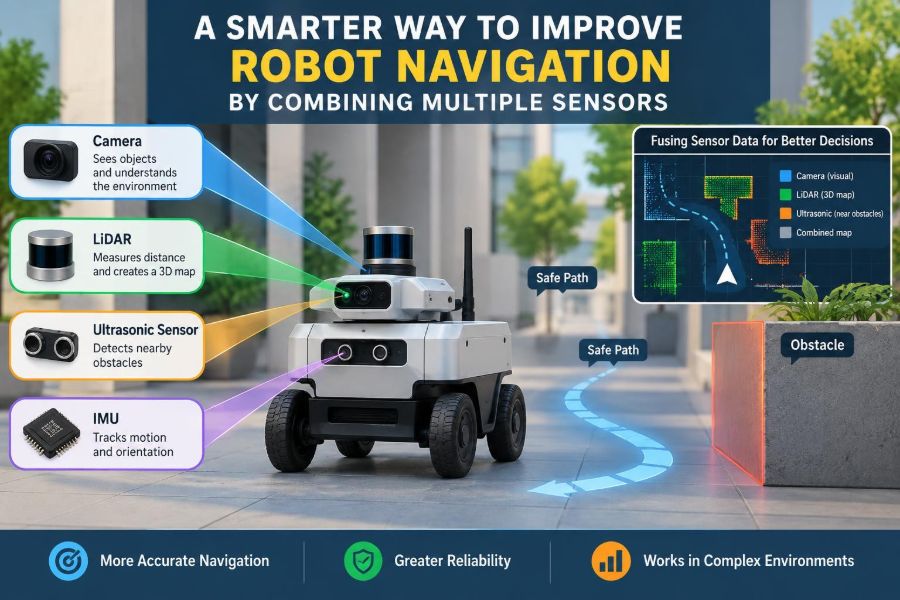
Every sensor measures a limited physical signal. A lidar measures distance using laser light, but usually cannot identify an object’s meaning by itself. A camera can reveal lane markings and signs, but its depth estimates may be uncertain.
Sensor fusion does not make sensors flawless. Instead, it combines complementary evidence while accounting for each measurement’s likely error, delay, coverage, and failure modes.
⚙️ Wheel Encoders Provide Motion Clues
Wheel encoders count wheel rotation. With wheel diameter and axle geometry, a robot can estimate how far it traveled and how much it turned. This process is called odometry.
Odometry is inexpensive and fast, making it useful for short-term motion tracking. Its weakness is cumulative error: a wheel slip, bump, or small calibration error can shift the estimate, and the error is carried forward.
🌀 IMUs Sense Fast Motion
An inertial measurement unit, or IMU, typically contains accelerometers and gyroscopes. Accelerometers measure specific force, while gyroscopes measure angular velocity. Together they help capture rapid turns, vibration, and short bursts of movement.
Integrating these signals over time produces velocity and position estimates, but small sensor biases grow into large drift. IMUs are therefore exceptionally valuable for fast updates, not as a permanent standalone position reference.
🛰️ GNSS Gives a Global Reference
Global Navigation Satellite System receivers, commonly called GPS in everyday speech, estimate location from satellite signals. Outdoors, they provide a valuable global reference that does not depend on wheel rotation or an existing local map.
Buildings, trees, tunnels, and reflected signals can reduce reliability. A navigation system should treat GNSS as a measurement with uncertainty, not as unquestionable ground truth.
📷 Cameras Add Rich Visual Context
Cameras capture texture, color, edges, signs, people, and semantic clues. A robot may use images to recognize a loading bay, follow a painted line, detect pedestrians, or estimate its movement from visual features.
However, image quality depends on lighting, exposure, motion blur, weather, and lens cleanliness. A camera can be highly informative while still being a poor choice as the only navigation sensor.
🌈 Depth Cameras Measure Nearby Structure
Depth cameras estimate the distance to visible surfaces, often using stereo vision, structured light, or time-of-flight sensing. They can produce dense local geometry that is useful for indoor obstacle avoidance and manipulation.
Range, sunlight sensitivity, reflective surfaces, and missing measurements vary by technology. Their outputs need filtering before a robot assumes every blank pixel represents open space.
🔦 Lidar Maps Geometry with Light
Lidar sends laser pulses and measures their return time to estimate distance. A two-dimensional lidar is common on indoor ground robots, while three-dimensional lidar captures a richer point cloud of the environment.
Lidar is often effective in low light and provides accurate geometric structure, but rain, fog, glass, highly absorbent materials, and moving objects can complicate readings. It also does not inherently distinguish a chair from a person.
📡 Radar Can See Through Difficult Conditions
Radar uses radio waves and can remain useful in conditions that challenge optical sensors, including some dust, fog, and rain. It can also estimate relative velocity through Doppler effects, which is especially useful for tracking moving vehicles.
Its spatial detail is commonly lower than camera or lidar detail. Fusion allows radar’s robust range and velocity cues to support more detailed sensors rather than forcing it to solve every perception task.
🧲 Other Sensors Have Specialized Roles
Magnetometers can provide a heading reference but are vulnerable to nearby motors, steel structures, and electrical equipment. Barometers can help estimate altitude changes, while ultrasonic sensors offer simple close-range detection.
These sensors are not obsolete because they are simple. In a well-designed system, a modest sensor can supply a useful independent check at exactly the range or condition where another sensor is weak.
🧩 Complementarity Matters More Than Sensor Count
Adding three sensors that fail in the same way may not improve safety much. A better combination contains genuinely different information sources: for example, wheel encoders for immediate motion, an IMU for rapid rotation, lidar for local geometry, and GNSS for outdoor global correction.
The goal is not to create a robot covered in hardware. The goal is to reduce important uncertainty with measurements that are relevant, sufficiently independent, and available when needed.
📊 Comparing Common Navigation Sensors
| Sensor | Strong contribution | Typical limitation | Useful fusion partner |
|---|---|---|---|
| Wheel encoder | Fast short-term travel estimate | Slip and accumulating drift | IMU, lidar, camera |
| IMU | Rapid orientation and motion changes | Bias drift over time | Encoder, GNSS, visual system |
| Camera | Object appearance and scene context | Lighting and depth ambiguity | Lidar, radar, IMU |
| Lidar | Accurate local geometry | Limited semantic meaning | Camera, encoder, IMU |
| GNSS | Global outdoor position reference | Blocked or reflected signals | IMU, encoder, map matching |
🧠 What Sensor Fusion Actually Produces
Fusion is often described as “combining sensor data,” but the output should be more specific. It may be a pose estimate, an occupancy grid showing likely obstacles, a tracked-object list, or a confidence value for each detected object.
A strong fusion system preserves uncertainty. Rather than claiming “the robot is here,” it represents a best estimate and how confident the system is in that estimate.
📐 Coordinate Frames Keep Measurements Meaningful
Sensor data only becomes useful when every measurement is expressed in a known coordinate frame. A camera may report an object relative to its lens, while a map uses world coordinates and the controller uses the robot’s body frame.
Rigid transformations connect these frames through measured sensor position and orientation. A small mounting-angle error can make a distant obstacle appear in the wrong lane or cause a map to slowly distort.
⏱️ Time Synchronization Is a Safety Issue
A measurement is not only a value; it is a value at a particular time. If a camera image is processed after the robot has moved, the system must associate it with the robot pose at image capture, not at the later processing time.
Unsynchronized streams create “ghost” errors: object tracks jump, map features smear, and a robot reacts to where an obstacle used to be. Hardware timestamps and disciplined clocks are often more valuable than an extra sensor.
🛠️ Calibration Aligns Sensors with Reality
Calibration estimates intrinsic properties such as camera lens parameters and extrinsic properties such as the physical transform between a lidar and a camera. It also includes scale factors, offsets, and biases in motion sensors.
Calibration is not a one-time ritual. Vibration, impacts, heat cycles, maintenance, and swapped components can change alignment. Systems should include verification procedures after relevant mechanical work.
🎯 State Estimation Turns Noisy Signals into a Pose
The state is the set of hidden quantities a robot needs to estimate, such as position, heading, velocity, and IMU bias. Sensors do not directly reveal all of these perfectly, so the system predicts a state and then corrects it with measurements.
This predict-and-correct cycle is the core idea behind many fusion approaches. The model says how the robot is expected to move; sensors say what the robot appears to have observed.
➗ Kalman Filters Offer a Useful Framework
A Kalman filter is a mathematical estimator that combines predictions and measurements according to their uncertainty. For nonlinear robot motion and sensors, engineers commonly use variants such as the extended Kalman filter or unscented Kalman filter.
If wheel odometry becomes unreliable on a slick surface, its uncertainty should increase, allowing a trusted external observation to have more influence. The filter should not merely average values; it should weigh evidence rationally.
🎲 Particle Filters Handle Multiple Possible Locations
Particle filters represent many possible robot poses, called particles, each with a weight. As new sensor observations arrive, particles that better match the observations gain weight while unlikely ones are discarded or resampled.
This approach is useful when a robot could plausibly be in several visually similar places, such as identical warehouse aisles. It can be computationally demanding, especially in large three-dimensional state spaces.
🗺️ SLAM Lets a Robot Map While Localizing
Simultaneous localization and mapping, or SLAM, estimates the robot’s pose while building a map of an unknown environment. The two tasks support each other: a better map improves localization, and a better pose makes map updates more coherent.
SLAM may use lidar scans, visual features, depth data, or combinations of these. It is powerful, but it still needs careful handling of moving objects, repeated structures, and sensor drift.
🔁 Loop Closure Corrects Long-Term Drift
When a robot recognizes a location it visited earlier, it can use that observation to correct accumulated mapping and pose error. This process is called loop closure.
Imagine drawing a building floor plan while walking with slightly inaccurate steps. Returning to the lobby provides evidence that the path should meet itself. False loop closures, however, can severely damage a map, so recognition must be conservative.
🚶 Static Maps and Dynamic Worlds Need Different Logic
Walls and fixed shelving are useful map features. People, forklifts, doors, carts, and other robots are dynamic objects that should not be permanently written into a static map.
A practical navigation stack separates long-lived environmental structure from short-lived obstacle observations. It then uses tracking to estimate where moving objects may be heading, rather than treating every sensor return as equally permanent.
🚦 Fusion Supports Both Planning Horizons
Global planning chooses a broad route through known space: perhaps from one warehouse zone to another. Local planning makes immediate decisions around nearby obstacles, speed limits, and uncertain terrain.
Different fused outputs serve each horizon. A globally corrected pose helps route planning, while fresh lidar, radar, and camera tracks help the local planner brake or steer safely in the next few seconds.
🏭 Example: An Indoor Warehouse Robot
Consider a hypothetical autonomous pallet mover. Wheel encoders and an IMU provide smooth high-rate motion estimates. A 2D lidar aligns incoming scans to a known map of fixed walls and rack structures.
Safety sensors detect close obstacles, while cameras may classify a pedestrian zone or read visual labels. If the wheels slip over dust, the lidar map alignment can pull the pose estimate back toward the correct aisle location.
🚗 Example: A Robot Moving Between Indoor and Outdoor Areas
A campus delivery robot may rely on GNSS and a camera-lidar map outdoors, then lose satellite quality as it enters a covered loading area. Its navigation system must transition gracefully rather than abruptly trusting a weak GNSS fix.
IMU, encoder, and local geometric observations bridge the gap. When satellite signals become trustworthy again, they can correct accumulated drift without causing a sudden, unsafe jump in the estimated pose.
⚠️ Sensor Disagreement Is Information, Not Just Noise
When two sensors disagree, the worst response is blindly averaging them. A disagreement may indicate wheel slip, a dirty camera lens, a blocked lidar window, incorrect calibration, or a timestamp problem.
Residual monitoring compares expected and observed measurements. Persistent abnormal residuals can trigger diagnostics, reduce a sensor’s influence, alert an operator, or place the robot in a conservative operating mode.
🧯 Redundancy Should Address Real Failure Modes
Redundancy means retaining a way to operate safely when a component degrades or fails. It does not always mean duplicating the same sensor. A second camera may share the first camera’s lighting vulnerability.
For a safety-critical task, engineers should ask what can fail together: power supply, software driver, network clock, mounting bracket, weather exposure, or environmental condition. Common-cause failures can defeat apparently redundant designs.
💻 Compute Limits Shape the Architecture
High-resolution cameras, dense point clouds, and deep-learning perception models can demand considerable processing power and create latency. A navigation system that makes an excellent decision too late may still be unsafe.
Engineers often separate time-critical sensing and control from heavier mapping or semantic tasks. They may reduce sensor rates, crop regions of interest, or use hardware acceleration, but only after measuring the impact on performance and failure behavior.
🧪 Test the Conditions the Robot Will Actually Face
Bench tests in a clean, static room reveal basic functionality, not robust navigation. Testing should include the actual environment’s lighting changes, reflective surfaces, vibration, traffic patterns, dust, route geometry, and communication dropouts.
Simulation is useful for exploring edge cases safely, but simulated sensors rarely reproduce every real artifact. Field testing should be staged, monitored, and paired with safe stop behavior.
📏 Define Metrics Before Tuning the System
Without clear metrics, teams can optimize a visually impressive demo while missing the operational problem. Relevant measures may include pose error against a trusted reference, obstacle-detection latency, map consistency, route completion behavior, and frequency of safe interventions.
Metrics should be tied to a use case. A robot that carries medication through a hospital has different acceptable behavior from a slow educational robot operating in a marked laboratory area.
🧱 Common Integration Mistakes
- Assuming factory calibration is permanent: installation geometry and mechanical changes matter.
- Ignoring latency: delayed data is especially damaging at higher speeds.
- Using confidence as decoration: uncertainty must influence planning and safety decisions.
- Training or tuning only in ideal conditions: real environments contain occlusion, clutter, and degraded signals.
- Overbuilding the sensor suite: extra hardware can add cost, calibration burden, and new failure paths without solving the key uncertainty.
🔒 Cybersecurity and Data Integrity Also Matter
Navigation depends on data that the robot trusts. A corrupted map, altered GNSS correction stream, compromised sensor driver, or manipulated network timestamp can affect localization and decisions.
Practical protections include authenticated updates, access control, logging, plausibility checks, and safe fallback behavior. Security engineering is not separate from navigation reliability when robots operate on connected systems.
🪜 A Practical Design Process for Sensor Fusion
- Define the operating environment, speed, payload, routes, and safety constraints.
- List navigation decisions the robot must make and the uncertainty that can prevent each one.
- Select complementary sensors based on those uncertainties and credible failure conditions.
- Design coordinate frames, timestamps, calibration procedures, and data-health checks early.
- Validate state estimation and perception separately before integrating planning behavior.
- Test degraded modes deliberately, then revise thresholds and fallback actions.
This process prevents a common mistake: selecting sensors first and only later trying to invent a problem they solve.
🎓 Skills Students and Practitioners Should Build
Effective fusion work sits between hardware and software. Useful foundations include probability, linear algebra, coordinate transformations, signal processing, control, embedded timing, and practical debugging.
Equally valuable is the habit of inspecting raw data. Plot encoder counts, IMU biases, point clouds, timestamps, and estimated poses. Many navigation failures become understandable long before an advanced algorithm is needed.
🌟 The Core Principle: Make Uncertainty Actionable
A smarter navigation system is not simply one with more sensors or a more elaborate algorithm. It is one that understands what each sensor can observe, when that observation is unreliable, and how uncertainty should change the robot’s actions.
Combining encoders, IMUs, cameras, lidar, radar, GNSS, and maps can create a resilient whole—but only when timing, calibration, modeling, diagnostics, and safety behavior receive the same attention as the sensor list.
Reliable robot navigation comes from combining complementary evidence, measuring its uncertainty, and responding safely when the evidence no longer agrees. That principle turns sensor fusion from a technical feature into a practical foundation for robots that can move through the real world with better judgment. 🦾🧭🤖